1940s Maps of Santa Ana, California
Explore 8 historic maps of Santa Ana from the 1940s. These maps offer a rare glimpse into what life looked like during the 1940s — showing old roads, neighborhoods, homes, and landmarks that have changed or disappeared over time.
Whether you're researching your family's past, planning a metal detecting trip, or studying how Santa Ana's landscape evolved across the 1940s, these high-resolution maps are a powerful tool for exploring the history of this region.
- Focus on a specific era: All maps on this page are from the 1940s, giving you a focused view of this time period.
- See what’s changed: Compare century-old streets, trails, and buildings to today's modern landscape using overlays and satellite layers.
- Research with precision: Use these maps for genealogy, historical research, land use analysis, or educational projects.
- View, download, or print: Maps are fully viewable online in high resolution, and can be downloaded or printed for your own records.
Start exploring Santa Ana's history through authentic maps from the 1940s. This is your window into the past.
Santa Ana, CA maps
(8)- 1942 Map of Anaheim
 1942 Anaheim1942 Print · USGSOrange County's agricultural heart is captured mid-century during a period of rapid wartime development. Genealogists can locate family landmarks like Diamond Bar Ranch, local schools such as Alamitos Sch, and communities like Garden Grove or Stanton.2 unique versions available
 - 1942 Map of Santa Ana
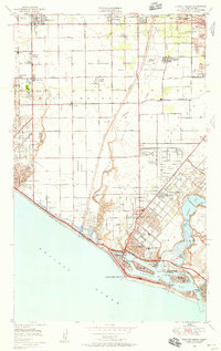
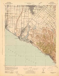 1942 Santa Ana1942 Print · USGSOrange County was still a landscape of coastal towns and sprawling citrus groves during the early years of the war. Genealogists and researchers can trace the early footprints of Costa Mesa, the rail-side industry of Sugar, and the distinct shorelines of Newport Bay.2 unique versions available
 - 1947 Map of Santa Ana, 1949 Print
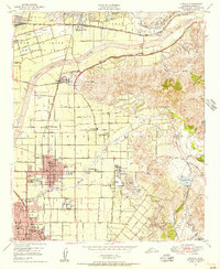
 1947 Santa Ana1949 Print · USGSSouthern California is depicted here in the late forties, showing the expansion of the Inland Empire and the Orange County coast. Researchers can trace the early layout of Palm Springs or locate long-standing tribal lands like the Pala Indian Reservation and Rincon Indian Res.
 - 1948 Map of Tustin, 1957 Print
 1948 Tustin1957 Print · USGSOrange County's agricultural heart was beginning to transform after the war as Tustin and the Irvine Ranch expanded toward the coast. Researchers can trace historic landmarks like Orange County Airport, the Naval Reservation, and old school sites like Delhi Sch.2 unique versions available
 - 1949 Map of Santa Ana
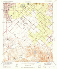
 1949 Santa Ana1949 Print · USGSSouthern California underwent a profound transformation in the late 1940s as military installations and citrus groves shared the landscape. Researchers can trace early coastal growth at Laguna Beach, military history at Camp Pendleton, and the rail corridors of the Pacific Electric.
 - 1949 Map of Anaheim, 1956 Print
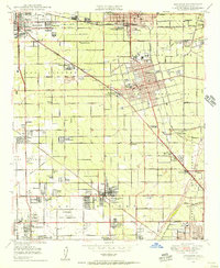 1949 Anaheim1956 Print · USGSMid-century Orange County is caught in transition from vast groves to suburban centers just before the arrival of major theme parks. Researchers can trace the legacy of local agriculture and early aviation at Haster Field, Colonia Independencia, and the POW Camp (Aband).
 - 1949 Map of Orange, 1956 Print
 1949 Orange1956 Print · USGSThe Orange and Santa Ana valley floor shows its transition from citrus groves to post-war suburbs during the late 1940s. Researchers can trace historic family burial sites at Fairhaven Cem or follow the old Southern Pacific line past Villa Park and El Modena.
 - 1949 Map of Newport Beach, 1958 Print
 1949 Newport Beach1958 Print · USGSThe Orange County coastline comes alive in this post-war survey, documenting the transition from oil fields to burgeoning seaside communities. Genealogists and historians can trace the foundations of Costa Mesa and Newport Beach while locating landmarks like Orange Coast College and the Pacific Electric railroad.
End of results
Showing maps 1-8 of 8
Top cities near Santa Ana
- Long Beach historical maps
- Anaheim historical maps
- Irvine historical maps
- Huntington Beach historical maps
- Garden Grove historical maps
- Corona historical maps
See more
Top neighborhoods of Santa Ana
- South Santa Ana historical maps
- South Coast historical maps
- Edna Park historical maps
- Dyer historical maps
- French Court historical maps
- French Park historical maps
See more
Frequently asked questions
- What are the different types of historical maps available for Santa Ana?
- What is the oldest map of Santa Ana?
- Where can I purchase historical maps of Santa Ana for my home or office?
- Where can I download high-res historical maps of Santa Ana?
- Are there historical topographic maps available for Santa Ana?
- Is there historical aerial imagery available for Santa Ana?
- Where are historical maps of Santa Ana sourced from?