1910s Maps of Lincoln, California
Explore 2 historic maps of Lincoln from the 1910s. These maps offer a rare glimpse into what life looked like during the 1910s — showing old roads, neighborhoods, homes, and landmarks that have changed or disappeared over time.
Whether you're researching your family's past, planning a metal detecting trip, or studying how Lincoln's landscape evolved across the 1910s, these high-resolution maps are a powerful tool for exploring the history of this region.
- Focus on a specific era: All maps on this page are from the 1910s, giving you a focused view of this time period.
- See what’s changed: Compare century-old streets, trails, and buildings to today's modern landscape using overlays and satellite layers.
- Research with precision: Use these maps for genealogy, historical research, land use analysis, or educational projects.
- View, download, or print: Maps are fully viewable online in high resolution, and can be downloaded or printed for your own records.
Start exploring Lincoln's history through authentic maps from the 1910s. This is your window into the past.
Lincoln, CA maps
(2)- 1910 Map of Lincoln
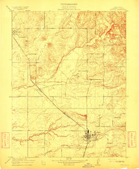 1910 Lincoln1910 Print · USGSPlacer County's lower foothills and agricultural plains are captured here just after the turn of the century. You can trace the path of the Southern Pacific (Marysville Line) through early settlements like Sheridan and Lincoln, and locate the old Fairoaks School.2 unique versions available
 - 1910 Map of Roseville
 1910 Roseville1910 Print · USGSRoseville was a burgeoning railroad town when this 1908 survey recorded its early street grid and rail junctions. Trace the tracks of the Southern Pacific through Whitney or locate rural landmarks like the Pleasant Grove School and Kaseberg farm.2 unique versions available
End of results
Showing maps 1-2 of 2
Top cities near Lincoln
- Sacramento historical maps
- Roseville historical maps
- Citrus Heights historical maps
- Folsom historical maps
- Rocklin historical maps
- El Dorado Hills historical maps
See more
Top neighborhoods of Lincoln
Frequently asked questions
- What are the different types of historical maps available for Lincoln?
- What is the oldest map of Lincoln?
- Where can I purchase historical maps of Lincoln for my home or office?
- Where can I download high-res historical maps of Lincoln?
- Are there historical topographic maps available for Lincoln?
- Is there historical aerial imagery available for Lincoln?
- Where are historical maps of Lincoln sourced from?