
1910 Map of Lincoln
USGS Topo · Published 1910About this map
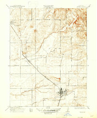
The settlement of Lincoln serves as the focal point of this Placer County survey, situated at the junction of several significant watercourses and rail lines. The Southern Pacific (Marysville Line) cuts diagonally across the landscape, connecting the regional hubs and supporting the local economy. Evidence of early industry is clearly marked by a Quarry located just north of the Lincoln townsite, while rural education is anchored by the Fairoaks School to the west.
Find a feature on this map
13 named features on this map. Tap any name to fly to it.
Don’t see what you’re looking for? This feature index may not catch every label — zoom into the map to look around manually.
Map Details
Editions of this 1910 Lincoln Map
2 editions found
Other maps of this area

1888 · Smartsville
USGS Topo · 1:125,000

1891 · Sacramento
USGS Topo · 1:125,000

1891 · Smartsville
USGS Topo · 1:125,000

1892 · Sacramento
USGS Topo · 1:125,000

1892 · Smartsville
USGS Topo · 1:125,000

1893 · Sacramento
USGS Topo · 1:125,000

1894 · Smartsville
USGS Topo · 1:125,000

1895 · Smartsville
USGS Topo · 1:125,000

1910 · Sheridan
USGS Topo · 1:31,680

1910 · Wheatland
USGS Topo · 1:31,680