1970s Maps of Graeagle, California
Explore 2 historic maps of Graeagle from the 1970s. These maps offer a rare glimpse into what life looked like during the 1970s — showing old roads, neighborhoods, homes, and landmarks that have changed or disappeared over time.
Whether you're researching your family's past, planning a metal detecting trip, or studying how Graeagle's landscape evolved across the 1970s, these high-resolution maps are a powerful tool for exploring the history of this region.
- Focus on a specific era: All maps on this page are from the 1970s, giving you a focused view of this time period.
- See what’s changed: Compare century-old streets, trails, and buildings to today's modern landscape using overlays and satellite layers.
- Research with precision: Use these maps for genealogy, historical research, land use analysis, or educational projects.
- View, download, or print: Maps are fully viewable online in high resolution, and can be downloaded or printed for your own records.
Start exploring Graeagle's history through authentic maps from the 1970s. This is your window into the past.
Graeagle, CA maps
(2)- 1972 Map of Blairsden, 1974 Print
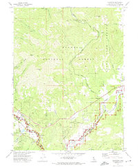 1972 Blairsden1974 Print · USGSPlumas County life in the early 1970s centered on the rail-and-river corridor through the Mohawk Valley. Researchers can trace the Western Pacific Railroad as it passes the settlements of Blairsden, Graeagle, and Mabie.2 unique versions available
 - 1979 Map of Portola, 1993 Print
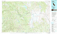 1979 Portola1993 Print · USGSThe northern Sierra Nevada and its timber-and-rail economy are captured here during the late seventies, spanning from the Feather River canyons to the high basins. Researchers can trace the path of the Western Pacific RR and locate historic hubs like Quincy, Portola, and Loyalton.2 unique versions available
End of results
Showing maps 1-2 of 2
Top cities near Graeagle
Frequently asked questions
- What are the different types of historical maps available for Graeagle?
- What is the oldest map of Graeagle?
- Where can I purchase historical maps of Graeagle for my home or office?
- Where can I download high-res historical maps of Graeagle?
- Are there historical topographic maps available for Graeagle?
- Is there historical aerial imagery available for Graeagle?
- Where are historical maps of Graeagle sourced from?