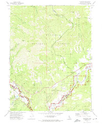
1972 Map of Blairsden
USGS Topo · Published 1974About this map
Blairsden and Graeagle anchor the southern reaches of this 1970s survey, where the Mohawk Valley meets the high elevations of the Plumas National Forest. The landscape is dominated by the steep drainage of the Middle Fork Feather Wild and Scenic River, which is paralleled by the tracks of the Western Pacific railroad. This corridor served as a vital transportation artery for the region's timber and recreational interests during the mid-20th century.
Find a feature on this map
41 named features on this map. Tap any name to fly to it.
Don’t see what you’re looking for? This feature index may not catch every label — zoom into the map to look around manually.
Map Details
Editions of this 1972 Blairsden Map
2 editions found
Other maps of this area

1890 · Sierraville
USGS Topo · 1:125,000

1891 · Downieville
USGS Topo · 1:125,000

1892 · Sierraville
USGS Topo · 1:125,000

1893 · Downieville
USGS Topo · 1:125,000

1894 · Sierraville
USGS Topo · 1:125,000

1895 · Downieville
USGS Topo · 1:125,000

1896 · Downieville
USGS Topo · 1:125,000

1897 · Downieville
USGS Topo · 1:125,000

1937 · Blairsden
USGS Topo · 1:48,000

1943 · Blairsden
USGS Topo · 1:62,500