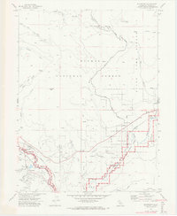
1972 Map of Blairsden
USGS Topo · Published 1974About this map
The Western Pacific railroad corridor serves as the primary artery through this section of Plumas County, connecting the settlements of Blairsden, Graeagle, and Delleker. This 1972 field-checked survey highlights the early development of recreational and industrial sites along the Middle Fork Feather River, including a Golf Course and several Gravel Pits. The topography is dominated by significant elevations such as Penman Peak and Smith Peak, the latter featuring a Lookout. Large portions of the terrain are designated as the State Game Refuge 1-V and Plumas National Forest, reflecting a landscape managed for both timber and wildlife conservation. Evidence of local infrastructure is seen in the Aqueduct near Graeagle and the small settlements of Mabie and Claireville Flat, which are situated along the river and rail lines.
Find a feature on this map
39 named features on this map. Tap any name to fly to it.
Don’t see what you’re looking for? This feature index may not catch every label — zoom into the map to look around manually.
Map Details
Editions of this 1972 Blairsden Map
2 editions found
Other maps of this area

1890 · Sierraville
USGS Topo · 1:125,000

1891 · Downieville
USGS Topo · 1:125,000

1892 · Sierraville
USGS Topo · 1:125,000

1893 · Downieville
USGS Topo · 1:125,000

1894 · Sierraville
USGS Topo · 1:125,000

1895 · Downieville
USGS Topo · 1:125,000

1896 · Downieville
USGS Topo · 1:125,000

1897 · Downieville
USGS Topo · 1:125,000

1937 · Blairsden
USGS Topo · 1:48,000

1943 · Blairsden
USGS Topo · 1:62,500