1970s Maps of Lake Elsinore, California
Explore 3 historic maps of Lake Elsinore from the 1970s. These maps offer a rare glimpse into what life looked like during the 1970s — showing old roads, neighborhoods, homes, and landmarks that have changed or disappeared over time.
Whether you're researching your family's past, planning a metal detecting trip, or studying how Lake Elsinore's landscape evolved across the 1970s, these high-resolution maps are a powerful tool for exploring the history of this region.
- Focus on a specific era: All maps on this page are from the 1970s, giving you a focused view of this time period.
- See what’s changed: Compare century-old streets, trails, and buildings to today's modern landscape using overlays and satellite layers.
- Research with precision: Use these maps for genealogy, historical research, land use analysis, or educational projects.
- View, download, or print: Maps are fully viewable online in high resolution, and can be downloaded or printed for your own records.
Start exploring Lake Elsinore's history through authentic maps from the 1970s. This is your window into the past.
Lake Elsinore, CA maps
(3)- 1974 Map of Alberhill, 1977 Print
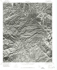 1974 Alberhill1977 Print · USGSThe Temescal Valley and surrounding highlands are captured in this mid-seventies orthophoto, showing the region's rugged geography. Trace the industrial footprint of Alberhill or follow the elevation change up to Trabuco Peak.
 - 1974 Map of Wildomar, 1977 Print
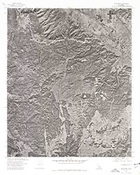 1974 Wildomar1977 Print · USGSWildomar and the surrounding foothills appear during a period of transition in the mid-1970s. Researchers can trace land development and natural drainage patterns through the Santa Ana Mountains and along Slaughterhouse Canyon.
 - 1974 Map of Elsinore, 1977 Print
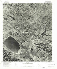 1974 Elsinore1977 Print · USGSRiverside County is captured in mid-seventies aerial detail during a period of steady expansion around its famous natural lake. Trace the development of Elsinore and Lakeland Village, or study the landscape around Railroad Canyon Reservoir.
End of results
Showing maps 1-3 of 3
Top cities near Lake Elsinore
- Riverside historical maps
- Moreno Valley historical maps
- Corona historical maps
- Murrieta historical maps
- Temecula historical maps
- Menifee historical maps
See more
Top neighborhoods of Lake Elsinore
- Terra Cotta historical maps
- Alberhill historical maps
- Alberhill Ranch historical maps
- North Elsinore historical maps
- Pinnacle historical maps
- The Terraces historical maps
Frequently asked questions
- What are the different types of historical maps available for Lake Elsinore?
- What is the oldest map of Lake Elsinore?
- Where can I purchase historical maps of Lake Elsinore for my home or office?
- Where can I download high-res historical maps of Lake Elsinore?
- Are there historical topographic maps available for Lake Elsinore?
- Is there historical aerial imagery available for Lake Elsinore?
- Where are historical maps of Lake Elsinore sourced from?