1990s Maps of Lake Elsinore, California
Explore 3 historic maps of Lake Elsinore from the 1990s. These maps offer a rare glimpse into what life looked like during the 1990s — showing old roads, neighborhoods, homes, and landmarks that have changed or disappeared over time.
Whether you're researching your family's past, planning a metal detecting trip, or studying how Lake Elsinore's landscape evolved across the 1990s, these high-resolution maps are a powerful tool for exploring the history of this region.
- Focus on a specific era: All maps on this page are from the 1990s, giving you a focused view of this time period.
- See what’s changed: Compare century-old streets, trails, and buildings to today's modern landscape using overlays and satellite layers.
- Research with precision: Use these maps for genealogy, historical research, land use analysis, or educational projects.
- View, download, or print: Maps are fully viewable online in high resolution, and can be downloaded or printed for your own records.
Start exploring Lake Elsinore's history through authentic maps from the 1990s. This is your window into the past.
Lake Elsinore, CA maps
(3)- 1997 Map of Lake Elsinore, 2000 Print
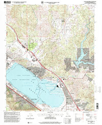 1997 Lake Elsinore2000 Print · USGSRiverside County at the close of the twentieth century shows a region balancing rapid suburban growth with its rugged topography. Genealogists and local historians can trace the development of Lakeland Village, locate the Elsinore Valley Cem, and find old sites like Terra Cotta or the Good Hope Mine.
 - 1997 Map of Wildomar, 2000 Print
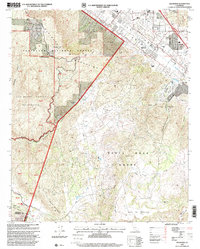 1997 Wildomar2000 Print · USGSRiverside County at the end of the nineties shows the suburban expansion of Wildomar meeting the edges of the Cleveland National Forest. Genealogists and historians can trace local family landmarks and rural outposts such as Morrell Ranch, the Santa Rosa Ranch, and the Cemetery.
 - 1997 Map of Alberhill, 2000 Print
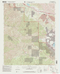 1997 Alberhill2000 Print · USGSThe industrial corridor of the Temescal Valley meets the Santa Ana Mountains in the late nineties. Local researchers can trace mining operations at the Old Dominion Mine and industrial sites like the Ceramic Factory and Clay Pit near Alberhill.2 unique versions available
End of results
Showing maps 1-3 of 3
Top cities near Lake Elsinore
- Riverside historical maps
- Moreno Valley historical maps
- Corona historical maps
- Murrieta historical maps
- Temecula historical maps
- Menifee historical maps
See more
Top neighborhoods of Lake Elsinore
- Terra Cotta historical maps
- Alberhill historical maps
- Alberhill Ranch historical maps
- North Elsinore historical maps
- Pinnacle historical maps
- The Terraces historical maps
Frequently asked questions
- What are the different types of historical maps available for Lake Elsinore?
- What is the oldest map of Lake Elsinore?
- Where can I purchase historical maps of Lake Elsinore for my home or office?
- Where can I download high-res historical maps of Lake Elsinore?
- Are there historical topographic maps available for Lake Elsinore?
- Is there historical aerial imagery available for Lake Elsinore?
- Where are historical maps of Lake Elsinore sourced from?