1980s Maps of Palm Springs, California
Explore 4 historic maps of Palm Springs from the 1980s. These maps offer a rare glimpse into what life looked like during the 1980s — showing old roads, neighborhoods, homes, and landmarks that have changed or disappeared over time.
Whether you're researching your family's past, planning a metal detecting trip, or studying how Palm Springs's landscape evolved across the 1980s, these high-resolution maps are a powerful tool for exploring the history of this region.
- Focus on a specific era: All maps on this page are from the 1980s, giving you a focused view of this time period.
- See what’s changed: Compare century-old streets, trails, and buildings to today's modern landscape using overlays and satellite layers.
- Research with precision: Use these maps for genealogy, historical research, land use analysis, or educational projects.
- View, download, or print: Maps are fully viewable online in high resolution, and can be downloaded or printed for your own records.
Start exploring Palm Springs's history through authentic maps from the 1980s. This is your window into the past.
Palm Springs, CA maps
(4)- 1981 Map of San Jacinto Peak, 1982 Print
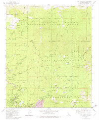 1981 San Jacinto Peak1982 Print · USGSThe mountain communities of Idyllwild and Fern Valley are captured here during the early eighties, surrounded by the high peaks of the San Jacinto Range. Researchers can trace the early path of the Pacific Crest National Scenic Trail or locate historical camps like Camp Lackey and Azalea Trails Camp.3 unique versions available
 - 1981 Map of Toro Peak, 1982 Print
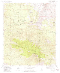 1981 Toro Peak1982 Print · USGSThe high Santa Rosa peaks and the San Bernardino National Forest were well-established as a mix of tribal lands and remote outposts by the early 1980s. Local historians can trace the development of Alpine Village, the Cactus Spring Trail, and the Santa Rosa Indian Reservation.3 unique versions available
 - 1981 Map of Palm View Peak, 1982 Print
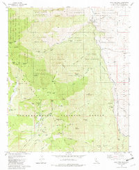 1981 Palm View Peak1982 Print · USGSRiverside County at the start of the 1980s reveals a transition from the peaks of the San Jacinto Mountains to the desert floor. Trace the Pacific Crest National Scenic Trail past landmarks like Fobes Ranch, Maynard Mine, and the Agua Caliente Indian Reservation.3 unique versions available
 - 1984 Map of Palm Springs, 1986 Print
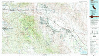 1984 Palm Springs1986 Print · USGSRiverside County’s desert resorts and valley agriculture are captured here in the mid-eighties as modern development expanded across the Coachella Valley. Genealogists and researchers can trace the growth of Palm Springs, locate family land near the Soboba Indian Reservation, or follow the Southern Pacific rail line through Banning.3 unique versions available
End of results
Showing maps 1-4 of 4
Top cities near Palm Springs
- Cathedral City historical maps
- Palm Desert historical maps
- Desert Hot Springs historical maps
- Rancho Mirage historical maps
- Indian Wells historical maps
- Idyllwild historical maps
See more
Top neighborhoods of Palm Springs
- Garnet historical maps
- Racquet Club Estates historical maps
- Twin Palms historical maps
- Old Las Palmas historical maps
- The Movie Colony historical maps
- The Mesa historical maps
See more
Frequently asked questions
- What are the different types of historical maps available for Palm Springs?
- What is the oldest map of Palm Springs?
- Where can I purchase historical maps of Palm Springs for my home or office?
- Where can I download high-res historical maps of Palm Springs?
- Are there historical topographic maps available for Palm Springs?
- Is there historical aerial imagery available for Palm Springs?
- Where are historical maps of Palm Springs sourced from?