1990s Maps of Palm Springs, California
Explore 6 historic maps of Palm Springs from the 1990s. These maps offer a rare glimpse into what life looked like during the 1990s — showing old roads, neighborhoods, homes, and landmarks that have changed or disappeared over time.
Whether you're researching your family's past, planning a metal detecting trip, or studying how Palm Springs's landscape evolved across the 1990s, these high-resolution maps are a powerful tool for exploring the history of this region.
- Focus on a specific era: All maps on this page are from the 1990s, giving you a focused view of this time period.
- See what’s changed: Compare century-old streets, trails, and buildings to today's modern landscape using overlays and satellite layers.
- Research with precision: Use these maps for genealogy, historical research, land use analysis, or educational projects.
- View, download, or print: Maps are fully viewable online in high resolution, and can be downloaded or printed for your own records.
Start exploring Palm Springs's history through authentic maps from the 1990s. This is your window into the past.
Palm Springs, CA maps
(6)- 1996 Map of Toro Peak, 1999 Print
 1996 Toro Peak1999 Print · USGSThe high San Jacinto and Santa Rosa ranges appear here in the mid-nineties, showing a landscape of mountain summits and desert flats. Researchers can trace remote sites like Alpine Village, Toro Camp, and the historic Santa Rosa Indian Reservation.3 unique versions available
 - 1996 Map of Palm Springs, 1999 Print
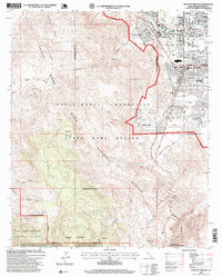
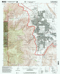 1996 Palm Springs1999 Print · USGSPalm Springs and the San Jacinto foothills appear in the late nineties, capturing the city's modern layout and local institutions. Researchers can locate the Agua Caliente Indian Reservation boundaries, find the local Cemetery, and trace landmarks like the Palm Springs Municipal Airport.
 - 1996 Map of Palm View Peak, 1999 Print
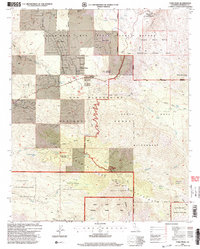
 1996 Palm View Peak1999 Print · USGSRiverside County's high desert peaks and canyons are captured in the mid-nineties as the wilderness and tribal lands intersect. Researchers can trace the Pacific Crest National Scenic Trail past Fobes Ranch and the remote Maynard Mine.
 - 1996 Map of San Jacinto Peak, 1999 Print
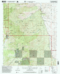
 1996 San Jacinto Peak1999 Print · USGSThe San Jacinto Mountains in the mid-nineties are a haven of high-country retreats and deep wilderness. Trace the development of Idyllwild and Pine Cove or explore the network of trails leading to San Jacinto Peak, Lily Rock, and Tahquitz Meadow.
 - 1996 Map of Rancho Mirage, 1999 Print
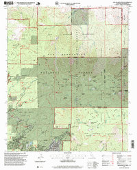
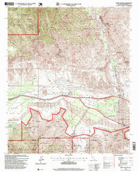
 1996 Rancho Mirage1999 Print · USGSRancho Mirage and Palm Desert are shown during a period of significant expansion, where upscale street grids meet the protected slopes of the Santa Rosa Mountains. Researchers can trace the development of El Paseo, the campus of the College of the Desert, and the secluded Shumway Ranch.
 - 1996 Map of White Water, 1999 Print
 1996 White Water1999 Print · USGSSan Gorgonio Pass in the late nineties serves as a vital artery for California's desert infrastructure and transit. Researchers can trace the path of the Colorado River Aqueduct and the Southern Pacific railroad past White Water PO and the Painted Hill Quarry.
End of results
Showing maps 1-6 of 6
Top cities near Palm Springs
- Cathedral City historical maps
- Palm Desert historical maps
- Desert Hot Springs historical maps
- Rancho Mirage historical maps
- Indian Wells historical maps
- Idyllwild historical maps
See more
Top neighborhoods of Palm Springs
- Garnet historical maps
- Racquet Club Estates historical maps
- Twin Palms historical maps
- Old Las Palmas historical maps
- The Movie Colony historical maps
- The Mesa historical maps
See more
Frequently asked questions
- What are the different types of historical maps available for Palm Springs?
- What is the oldest map of Palm Springs?
- Where can I purchase historical maps of Palm Springs for my home or office?
- Where can I download high-res historical maps of Palm Springs?
- Are there historical topographic maps available for Palm Springs?
- Is there historical aerial imagery available for Palm Springs?
- Where are historical maps of Palm Springs sourced from?