1990s Maps of Yampa Ranch, California
Explore 1 historic maps of Yampa Ranch from the 1990s. These maps offer a rare glimpse into what life looked like during the 1990s — showing old roads, neighborhoods, homes, and landmarks that have changed or disappeared over time.
Whether you're researching your family's past, planning a metal detecting trip, or studying how Yampa Ranch's landscape evolved across the 1990s, these high-resolution maps are a powerful tool for exploring the history of this region.
- Focus on a specific era: All maps on this page are from the 1990s, giving you a focused view of this time period.
- See what’s changed: Compare century-old streets, trails, and buildings to today's modern landscape using overlays and satellite layers.
- Research with precision: Use these maps for genealogy, historical research, land use analysis, or educational projects.
- View, download, or print: Maps are fully viewable online in high resolution, and can be downloaded or printed for your own records.
Start exploring Yampa Ranch's history through authentic maps from the 1990s. This is your window into the past.
Yampa Ranch, CA maps
(1)- 1997 Map of Pechanga, 2000 Print
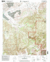 1997 Pechanga2000 Print · USGSRiverside and San Diego counties met in the 1990s at a crossroads of tribal lands and mountain wilderness. Genealogists and historians can trace the geography of the Pechanga Indian Reservation and locate historic gem sites like the Pala Chief Mine and Tourmaline Queen Mine.
End of results
Showing maps 1-1 of 1
Top cities near Yampa Ranch
- Murrieta historical maps
- Temecula historical maps
- Vista historical maps
- Menifee historical maps
- Hemet historical maps
- Lake Elsinore historical maps
See more
Frequently asked questions
- What are the different types of historical maps available for Yampa Ranch?
- What is the oldest map of Yampa Ranch?
- Where can I purchase historical maps of Yampa Ranch for my home or office?
- Where can I download high-res historical maps of Yampa Ranch?
- Are there historical topographic maps available for Yampa Ranch?
- Is there historical aerial imagery available for Yampa Ranch?
- Where are historical maps of Yampa Ranch sourced from?