1960s Maps of Bitterwater, California
Explore 2 historic maps of Bitterwater from the 1960s. These maps offer a rare glimpse into what life looked like during the 1960s — showing old roads, neighborhoods, homes, and landmarks that have changed or disappeared over time.
Whether you're researching your family's past, planning a metal detecting trip, or studying how Bitterwater's landscape evolved across the 1960s, these high-resolution maps are a powerful tool for exploring the history of this region.
- Focus on a specific era: All maps on this page are from the 1960s, giving you a focused view of this time period.
- See what’s changed: Compare century-old streets, trails, and buildings to today's modern landscape using overlays and satellite layers.
- Research with precision: Use these maps for genealogy, historical research, land use analysis, or educational projects.
- View, download, or print: Maps are fully viewable online in high resolution, and can be downloaded or printed for your own records.
Start exploring Bitterwater's history through authentic maps from the 1960s. This is your window into the past.
Bitterwater, CA maps
(2)- 1965 Map of Santa Cruz, 1968 Print
 1965 Santa Cruz1968 Print · USGSThe Central Coast and San Joaquin Valley meet here during the mid-sixties, capturing the growth of agricultural and coastal hubs. Trace the historic Southern Pacific RR lines and locate sites like the Presidio of Monterey or Pinnacles National Monument.
 - 1969 Map of Topo Valley, 1973 Print
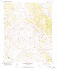 1969 Topo Valley1973 Print · USGSSan Benito and Monterey counties are captured in the late sixties at the intersection of geology and ranching life. Genealogists and historians can trace family land at Sans Ranch, locate the remote Murphy Flat, or study the San Andreas Rift Zone.2 unique versions available
End of results
Showing maps 1-2 of 2
Top cities near Bitterwater
Frequently asked questions
- What are the different types of historical maps available for Bitterwater?
- What is the oldest map of Bitterwater?
- Where can I purchase historical maps of Bitterwater for my home or office?
- Where can I download high-res historical maps of Bitterwater?
- Are there historical topographic maps available for Bitterwater?
- Is there historical aerial imagery available for Bitterwater?
- Where are historical maps of Bitterwater sourced from?