1960s Maps of Atolia, California
Explore 2 historic maps of Atolia from the 1960s. These maps offer a rare glimpse into what life looked like during the 1960s — showing old roads, neighborhoods, homes, and landmarks that have changed or disappeared over time.
Whether you're researching your family's past, planning a metal detecting trip, or studying how Atolia's landscape evolved across the 1960s, these high-resolution maps are a powerful tool for exploring the history of this region.
- Focus on a specific era: All maps on this page are from the 1960s, giving you a focused view of this time period.
- See what’s changed: Compare century-old streets, trails, and buildings to today's modern landscape using overlays and satellite layers.
- Research with precision: Use these maps for genealogy, historical research, land use analysis, or educational projects.
- View, download, or print: Maps are fully viewable online in high resolution, and can be downloaded or printed for your own records.
Start exploring Atolia's history through authentic maps from the 1960s. This is your window into the past.
Atolia, CA maps
(2)- 1960 Map of Trona
 1960 Trona1960 Print · USGSThe Mojave Desert at mid-century reveals a landscape of massive military installations and industrial mineral works. Researchers can trace the heritage of mining and ranching at Ashford Mill, Randsburg, and Paxton Ranch while following the Old Spanish Trail.2 unique versions available
 - 1967 Map of Red Mountain, 1969 Print
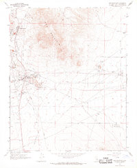 1967 Red Mountain1969 Print · USGSSan Bernardino County mining camps and military ranges are captured here in the late sixties. Researchers can trace the extensive industrial footprint at Atolia, locate the St Elmo Mine, and follow the Old Railroad Grade through the desert.3 unique versions available
End of results
Showing maps 1-2 of 2
Top cities near Atolia
Frequently asked questions
- What are the different types of historical maps available for Atolia?
- What is the oldest map of Atolia?
- Where can I purchase historical maps of Atolia for my home or office?
- Where can I download high-res historical maps of Atolia?
- Are there historical topographic maps available for Atolia?
- Is there historical aerial imagery available for Atolia?
- Where are historical maps of Atolia sourced from?