1940s Maps of Goffs, California
Explore 3 historic maps of Goffs from the 1940s. These maps offer a rare glimpse into what life looked like during the 1940s — showing old roads, neighborhoods, homes, and landmarks that have changed or disappeared over time.
Whether you're researching your family's past, planning a metal detecting trip, or studying how Goffs's landscape evolved across the 1940s, these high-resolution maps are a powerful tool for exploring the history of this region.
- Focus on a specific era: All maps on this page are from the 1940s, giving you a focused view of this time period.
- See what’s changed: Compare century-old streets, trails, and buildings to today's modern landscape using overlays and satellite layers.
- Research with precision: Use these maps for genealogy, historical research, land use analysis, or educational projects.
- View, download, or print: Maps are fully viewable online in high resolution, and can be downloaded or printed for your own records.
Start exploring Goffs's history through authentic maps from the 1940s. This is your window into the past.
Goffs, CA maps
(3)- 1942 Map of Amboy
 1942 Amboy1942 Print · USGSSan Bernardino's high desert reveals its rail-and-road bones in the 1940s as transcontinental traffic pulses along the iconic route 66. Researchers can trace the water sources and small stations that made desert life possible, from Bonanza King Well and Wilhelm Camp to the rail stops at Amboy and Cadiz.
 - 1943 Map of Amboy
 1943 Amboy1943 Print · USGSThe Mojave Desert during the Second World War reveals a landscape of critical military training and vital rail infrastructure. Genealogists and historians can trace desert outposts like Bolo Station, the industrial Lime Mine Refinery, and the wartime 3rd Armd Div Camp.
 - 1943 Map of Fenner
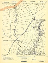 1943 Fenner1943 Print · USGSSan Bernardino County was a critical training ground during the early 1940s, with this survey mapping the essential rail and water points. Researchers can trace the path of the Atchison Topeka and Santa Fe through desert stops like Goffs and Fenner.
End of results
Showing maps 1-3 of 3
Frequently asked questions
- What are the different types of historical maps available for Goffs?
- What is the oldest map of Goffs?
- Where can I purchase historical maps of Goffs for my home or office?
- Where can I download high-res historical maps of Goffs?
- Are there historical topographic maps available for Goffs?
- Is there historical aerial imagery available for Goffs?
- Where are historical maps of Goffs sourced from?