1940s Maps of Houze Place, California
Explore 2 historic maps of Houze Place from the 1940s. These maps offer a rare glimpse into what life looked like during the 1940s — showing old roads, neighborhoods, homes, and landmarks that have changed or disappeared over time.
Whether you're researching your family's past, planning a metal detecting trip, or studying how Houze Place's landscape evolved across the 1940s, these high-resolution maps are a powerful tool for exploring the history of this region.
- Focus on a specific era: All maps on this page are from the 1940s, giving you a focused view of this time period.
- See what’s changed: Compare century-old streets, trails, and buildings to today's modern landscape using overlays and satellite layers.
- Research with precision: Use these maps for genealogy, historical research, land use analysis, or educational projects.
- View, download, or print: Maps are fully viewable online in high resolution, and can be downloaded or printed for your own records.
Start exploring Houze Place's history through authentic maps from the 1940s. This is your window into the past.
Houze Place, CA maps
(2)- 1942 Map of Kramer
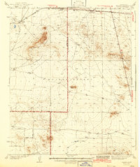 1942 Kramer1942 Print · USGSThe high desert comes into focus in the 1930s and 40s as rail transit and early aviation began to shape this corner of San Bernardino. You can trace the Atchison Topeka and Santa Fe tracks through Amargo or find the remote Blake Ranch and Kramer.2 unique versions available
 - 1947 Map of Kramer SW
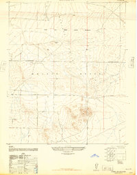 1947 Kramer SW1947 Print · USGSLos Angeles County's high desert reveals its early military footprint in the years just after the war. Researchers can trace the boundaries of Muroc Army Airfield Military Reservation and locate specific features like Jackrabbit Hill and the northern Target area.3 unique versions available
End of results
Showing maps 1-2 of 2
Top cities near Houze Place
Frequently asked questions
- What are the different types of historical maps available for Houze Place?
- What is the oldest map of Houze Place?
- Where can I purchase historical maps of Houze Place for my home or office?
- Where can I download high-res historical maps of Houze Place?
- Are there historical topographic maps available for Houze Place?
- Is there historical aerial imagery available for Houze Place?
- Where are historical maps of Houze Place sourced from?