1940s Maps of Mount Baldy, California
Explore 2 historic maps of Mount Baldy from the 1940s. These maps offer a rare glimpse into what life looked like during the 1940s — showing old roads, neighborhoods, homes, and landmarks that have changed or disappeared over time.
Whether you're researching your family's past, planning a metal detecting trip, or studying how Mount Baldy's landscape evolved across the 1940s, these high-resolution maps are a powerful tool for exploring the history of this region.
- Focus on a specific era: All maps on this page are from the 1940s, giving you a focused view of this time period.
- See what’s changed: Compare century-old streets, trails, and buildings to today's modern landscape using overlays and satellite layers.
- Research with precision: Use these maps for genealogy, historical research, land use analysis, or educational projects.
- View, download, or print: Maps are fully viewable online in high resolution, and can be downloaded or printed for your own records.
Start exploring Mount Baldy's history through authentic maps from the 1940s. This is your window into the past.
Mount Baldy, CA maps
(2)- 1940 Map of Camp Baldy
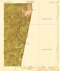 1940 Camp Baldy1940 Print · USGSMount Baldy’s early high-altitude culture and canyon mining are frozen in time just before the mid-century. Researchers can trace the paths to the Gold Dollar Mine, locate the Camp Baldy Guard Station, and see the early route of Baldy Road.3 unique versions available
 - 1944 Map of Cucamonga
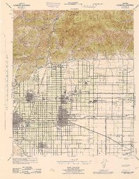 1944 Cucamonga1944 Print · USGSThe San Gabriel Valley and Inland Empire are shown here during the mid-forties, capturing the peak of the region's citrus era and rail-based transit. Researchers can trace early campus layouts at Pomona College or locate vanished landmarks like the Monta Vista Resort and Padua Hills Theater.
End of results
Showing maps 1-2 of 2
Top cities near Mount Baldy
- Riverside historical maps
- Fontana historical maps
- Ontario historical maps
- Rancho Cucamonga historical maps
- Pomona historical maps
- Victorville historical maps
See more
Frequently asked questions
- What are the different types of historical maps available for Mount Baldy?
- What is the oldest map of Mount Baldy?
- Where can I purchase historical maps of Mount Baldy for my home or office?
- Where can I download high-res historical maps of Mount Baldy?
- Are there historical topographic maps available for Mount Baldy?
- Is there historical aerial imagery available for Mount Baldy?
- Where are historical maps of Mount Baldy sourced from?