1960s Maps of Piñon Hills, California
Explore 2 historic maps of Piñon Hills from the 1960s. These maps offer a rare glimpse into what life looked like during the 1960s — showing old roads, neighborhoods, homes, and landmarks that have changed or disappeared over time.
Whether you're researching your family's past, planning a metal detecting trip, or studying how Piñon Hills's landscape evolved across the 1960s, these high-resolution maps are a powerful tool for exploring the history of this region.
- Focus on a specific era: All maps on this page are from the 1960s, giving you a focused view of this time period.
- See what’s changed: Compare century-old streets, trails, and buildings to today's modern landscape using overlays and satellite layers.
- Research with precision: Use these maps for genealogy, historical research, land use analysis, or educational projects.
- View, download, or print: Maps are fully viewable online in high resolution, and can be downloaded or printed for your own records.
Start exploring Piñon Hills's history through authentic maps from the 1960s. This is your window into the past.
Piñon Hills, CA maps
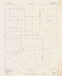
(2)- 1966 Map of San Bernardino
 1966 San Bernardino1966 Print · USGSThe San Bernardino Valley and Mojave Desert met during a period of massive military and suburban growth in the mid-sixties. Genealogists and historians can trace the development of Edwards Air Force Base, old desert mines like the Bagdad Chase Mine, and mountain communities near Big Bear Lake.
 - 1968 Map of El Mirage, 1969 Print
 1968 El Mirage1969 Print · USGSEl Mirage Valley and the high desert borderlands are shown here in the late sixties as aviation and rail infrastructure reshaped the landscape. Researchers can find the 36 Field (Abandoned) airfield, the Southern Pacific railroad line, and local landmarks like Black Butte.
End of results
Showing maps 1-2 of 2
Top cities near Piñon Hills
- Victorville historical maps
- Hesperia historical maps
- Adelanto historical maps
- Wrightwood historical maps
Top neighborhoods of Piñon Hills
- Pinon Hills Estates historical maps
- Wildhorse Canyon historical maps
- Deer Haven historical maps
- Yucca Inn historical maps
Frequently asked questions
- What are the different types of historical maps available for Piñon Hills?
- What is the oldest map of Piñon Hills?
- Where can I purchase historical maps of Piñon Hills for my home or office?
- Where can I download high-res historical maps of Piñon Hills?
- Are there historical topographic maps available for Piñon Hills?
- Is there historical aerial imagery available for Piñon Hills?
- Where are historical maps of Piñon Hills sourced from?