1960s Maps of Yucaipa, California
Explore 3 historic maps of Yucaipa from the 1960s. These maps offer a rare glimpse into what life looked like during the 1960s — showing old roads, neighborhoods, homes, and landmarks that have changed or disappeared over time.
Whether you're researching your family's past, planning a metal detecting trip, or studying how Yucaipa's landscape evolved across the 1960s, these high-resolution maps are a powerful tool for exploring the history of this region.
- Focus on a specific era: All maps on this page are from the 1960s, giving you a focused view of this time period.
- See what’s changed: Compare century-old streets, trails, and buildings to today's modern landscape using overlays and satellite layers.
- Research with precision: Use these maps for genealogy, historical research, land use analysis, or educational projects.
- View, download, or print: Maps are fully viewable online in high resolution, and can be downloaded or printed for your own records.
Start exploring Yucaipa's history through authentic maps from the 1960s. This is your window into the past.
Yucaipa, CA maps
(3)- 1966 Map of San Bernardino
 1966 San Bernardino1966 Print · USGSThe San Bernardino Valley and Mojave Desert met during a period of massive military and suburban growth in the mid-sixties. Genealogists and historians can trace the development of Edwards Air Force Base, old desert mines like the Bagdad Chase Mine, and mountain communities near Big Bear Lake.
 - 1967 Map of Yucaipa, 1968 Print
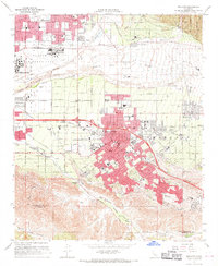
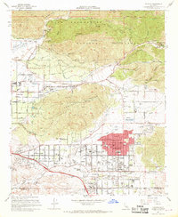 1967 Yucaipa1968 Print · USGSThe Yucaipa Valley is captured in the late 1960s during a period of rapid suburban expansion near the foothills of the San Bernardino Mountains. Researchers can trace development through old schools like Yucaipa High Sch and landmarks such as the Crafton Hills Airport.4 unique versions available
 - 1967 Map of Redlands, 1969 Print
 1967 Redlands1969 Print · USGSRedlands and its surrounding citrus communities are captured in the late sixties, a period of significant suburban expansion in San Bernardino County. Researchers can trace the layout of Norton Air Force Base, find local landmarks like the University of Redlands, or locate family sites near Harlem Springs and Bryn Mawr.6 unique versions available
End of results
Showing maps 1-3 of 3
Top cities near Yucaipa
- Moreno Valley historical maps
- Redlands historical maps
- Highland historical maps
- Perris historical maps
- San Jacinto historical maps
- Banning historical maps
See more
Top neighborhoods of Yucaipa
Frequently asked questions
- What are the different types of historical maps available for Yucaipa?
- What is the oldest map of Yucaipa?
- Where can I purchase historical maps of Yucaipa for my home or office?
- Where can I download high-res historical maps of Yucaipa?
- Are there historical topographic maps available for Yucaipa?
- Is there historical aerial imagery available for Yucaipa?
- Where are historical maps of Yucaipa sourced from?