1940s Maps of Canyon City, California
Explore 2 historic maps of Canyon City from the 1940s. These maps offer a rare glimpse into what life looked like during the 1940s — showing old roads, neighborhoods, homes, and landmarks that have changed or disappeared over time.
Whether you're researching your family's past, planning a metal detecting trip, or studying how Canyon City's landscape evolved across the 1940s, these high-resolution maps are a powerful tool for exploring the history of this region.
- Focus on a specific era: All maps on this page are from the 1940s, giving you a focused view of this time period.
- See what’s changed: Compare century-old streets, trails, and buildings to today's modern landscape using overlays and satellite layers.
- Research with precision: Use these maps for genealogy, historical research, land use analysis, or educational projects.
- View, download, or print: Maps are fully viewable online in high resolution, and can be downloaded or printed for your own records.
Start exploring Canyon City's history through authentic maps from the 1940s. This is your window into the past.
Canyon City, CA maps
(2)- 1942 Map of Potrero
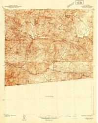 1942 Potrero1942 Print · USGSThe southern California borderlands come into focus during the early 1940s, showing the complex terrain of the Cleveland National Forest. Genealogists and historians can trace rural schoolhouses like Potrero Sch, the path of the San Diego & Arizona Eastern RR, and the border crossing at Tecate.
 - 1944 Map of Potrero
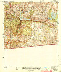 1944 Potrero1944 Print · USGSThe San Diego backcountry and the international border come into focus during the early 1940s. Local historians and genealogists can trace the rural layout of Potrero, locate the Custom House at Tecate, and follow the San Diego & Arizona Eastern rail line.2 unique versions available
End of results
Showing maps 1-2 of 2
Top cities near Canyon City
Frequently asked questions
- What are the different types of historical maps available for Canyon City?
- What is the oldest map of Canyon City?
- Where can I purchase historical maps of Canyon City for my home or office?
- Where can I download high-res historical maps of Canyon City?
- Are there historical topographic maps available for Canyon City?
- Is there historical aerial imagery available for Canyon City?
- Where are historical maps of Canyon City sourced from?