1960s Maps of Canyon City, California
Explore 2 historic maps of Canyon City from the 1960s. These maps offer a rare glimpse into what life looked like during the 1960s — showing old roads, neighborhoods, homes, and landmarks that have changed or disappeared over time.
Whether you're researching your family's past, planning a metal detecting trip, or studying how Canyon City's landscape evolved across the 1960s, these high-resolution maps are a powerful tool for exploring the history of this region.
- Focus on a specific era: All maps on this page are from the 1960s, giving you a focused view of this time period.
- See what’s changed: Compare century-old streets, trails, and buildings to today's modern landscape using overlays and satellite layers.
- Research with precision: Use these maps for genealogy, historical research, land use analysis, or educational projects.
- View, download, or print: Maps are fully viewable online in high resolution, and can be downloaded or printed for your own records.
Start exploring Canyon City's history through authentic maps from the 1960s. This is your window into the past.
Canyon City, CA maps
(2)- 1960 Map of Potrero, 1961 Print
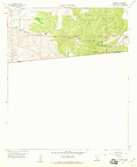 1960 Potrero1961 Print · USGSThe San Diego backcountry at the dawn of the 1960s reveals a sparse landscape of mountain valleys and border settlements. Trace the winding San Diego and Arizona Eastern Railway through Canyon City or locate the old Cem in Potrero.4 unique versions available
 - 1960 Map of Potrero, 1962 Print
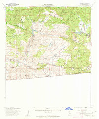 1960 Potrero1962 Print · USGSSouthern San Diego County's high country and borderlands are mapped here in the early sixties within the Cleveland National Forest. Researchers can trace the water systems of Morena Reservoir, find old family sites like Bratton Ranch, and locate the historic Barrett Sch.2 unique versions available
End of results
Showing maps 1-2 of 2
Top cities near Canyon City
Frequently asked questions
- What are the different types of historical maps available for Canyon City?
- What is the oldest map of Canyon City?
- Where can I purchase historical maps of Canyon City for my home or office?
- Where can I download high-res historical maps of Canyon City?
- Are there historical topographic maps available for Canyon City?
- Is there historical aerial imagery available for Canyon City?
- Where are historical maps of Canyon City sourced from?