1940s Maps of Chula Vista, California
Explore 3 historic maps of Chula Vista from the 1940s. These maps offer a rare glimpse into what life looked like during the 1940s — showing old roads, neighborhoods, homes, and landmarks that have changed or disappeared over time.
Whether you're researching your family's past, planning a metal detecting trip, or studying how Chula Vista's landscape evolved across the 1940s, these high-resolution maps are a powerful tool for exploring the history of this region.
- Focus on a specific era: All maps on this page are from the 1940s, giving you a focused view of this time period.
- See what’s changed: Compare century-old streets, trails, and buildings to today's modern landscape using overlays and satellite layers.
- Research with precision: Use these maps for genealogy, historical research, land use analysis, or educational projects.
- View, download, or print: Maps are fully viewable online in high resolution, and can be downloaded or printed for your own records.
Start exploring Chula Vista's history through authentic maps from the 1940s. This is your window into the past.
Chula Vista, CA maps
(3)- 1943 Map of San Ysidro
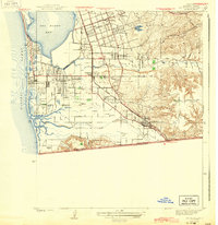 1943 San Ysidro1943 Print · USGSThe Southern California borderlands during the early 1940s reveal a mix of coastal defense, salt harvesting, and emerging towns. Researchers can trace the rail lines through San Ysidro Station or locate family landmarks like Howard Ranch and Emory Sch.2 unique versions available
 - 1943 Map of Jamul
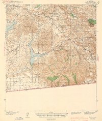 1943 Jamul1943 Print · USGSSouthern San Diego County ranching and water history is captured here at the start of the 1940s. Genealogists and local historians can trace family holdings like Ivanhoe Ranch and Otay Ranch alongside community landmarks such as Dulzura Sch and the Camp Minnewawa CCC camp.
 - 1944 Map of National City
 1944 National City1944 Print · USGSPost-war San Diego County comes alive in this survey of the South Bay and its inland valleys. Genealogists and historians can trace family plots at Holy Cross Cem, the growth of Lincoln Acres, or the operations of the Chollas Heights Naval Radio Sta.
End of results
Showing maps 1-3 of 3
Top cities near Chula Vista
- San Diego historical maps
- El Cajon historical maps
- La Mesa historical maps
- Santee historical maps
- National City historical maps
- La Presa historical maps
See more
Top neighborhoods of Chula Vista
- Harbor Side historical maps
- Rancho del Rey historical maps
- Sunny Vista historical maps
- Eastlake Greens historical maps
- Wolf Canyon historical maps
- Cota Vera historical maps
See more
Frequently asked questions
- What are the different types of historical maps available for Chula Vista?
- What is the oldest map of Chula Vista?
- Where can I purchase historical maps of Chula Vista for my home or office?
- Where can I download high-res historical maps of Chula Vista?
- Are there historical topographic maps available for Chula Vista?
- Is there historical aerial imagery available for Chula Vista?
- Where are historical maps of Chula Vista sourced from?