1940s Maps of Clover Flat, California
Explore 1 historic maps of Clover Flat from the 1940s. These maps offer a rare glimpse into what life looked like during the 1940s — showing old roads, neighborhoods, homes, and landmarks that have changed or disappeared over time.
Whether you're researching your family's past, planning a metal detecting trip, or studying how Clover Flat's landscape evolved across the 1940s, these high-resolution maps are a powerful tool for exploring the history of this region.
- Focus on a specific era: All maps on this page are from the 1940s, giving you a focused view of this time period.
- See what’s changed: Compare century-old streets, trails, and buildings to today's modern landscape using overlays and satellite layers.
- Research with precision: Use these maps for genealogy, historical research, land use analysis, or educational projects.
- View, download, or print: Maps are fully viewable online in high resolution, and can be downloaded or printed for your own records.
Start exploring Clover Flat's history through authentic maps from the 1940s. This is your window into the past.
Clover Flat, CA maps
(1)- 1942 Map of Campo, 1944 Print
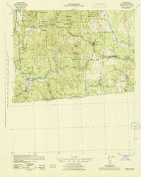 1942 Campo1944 Print · USGSThe international border and the winding route of the San Diego and Arizona Eastern railroad define this mountain region during the early 1940s. Genealogists and local historians can trace family locations at Castle Rock Ranch, Boulder Oaks, and the Hipass Station rail stop.
End of results
Showing maps 1-1 of 1
Top cities near Clover Flat
- Campo historical maps
- Pine Valley historical maps
- Descanso historical maps
- Potrero historical maps
- Boulevard historical maps
- Tecate historical maps
See more
Frequently asked questions
- What are the different types of historical maps available for Clover Flat?
- What is the oldest map of Clover Flat?
- Where can I purchase historical maps of Clover Flat for my home or office?
- Where can I download high-res historical maps of Clover Flat?
- Are there historical topographic maps available for Clover Flat?
- Is there historical aerial imagery available for Clover Flat?
- Where are historical maps of Clover Flat sourced from?