1990s Maps of Dehesa, California
Explore 1 historic maps of Dehesa from the 1990s. These maps offer a rare glimpse into what life looked like during the 1990s — showing old roads, neighborhoods, homes, and landmarks that have changed or disappeared over time.
Whether you're researching your family's past, planning a metal detecting trip, or studying how Dehesa's landscape evolved across the 1990s, these high-resolution maps are a powerful tool for exploring the history of this region.
- Focus on a specific era: All maps on this page are from the 1990s, giving you a focused view of this time period.
- See what’s changed: Compare century-old streets, trails, and buildings to today's modern landscape using overlays and satellite layers.
- Research with precision: Use these maps for genealogy, historical research, land use analysis, or educational projects.
- View, download, or print: Maps are fully viewable online in high resolution, and can be downloaded or printed for your own records.
Start exploring Dehesa's history through authentic maps from the 1990s. This is your window into the past.
Dehesa, CA maps
(1)- 1997 Map of Alpine, 2000 Print
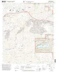 1997 Alpine2000 Print · USGSThe San Diego foothills near Alpine appear in the late nineties as a blend of growing residential communities and expansive federal and tribal lands. Researchers can trace the boundaries of the Sycuan Indian Reservation or locate family landmarks like McClain Ranch and Murphy Ranch.
End of results
Showing maps 1-1 of 1
Top cities near Dehesa
- San Diego historical maps
- Chula Vista historical maps
- El Cajon historical maps
- La Mesa historical maps
- Santee historical maps
- National City historical maps
See more
Frequently asked questions
- What are the different types of historical maps available for Dehesa?
- What is the oldest map of Dehesa?
- Where can I purchase historical maps of Dehesa for my home or office?
- Where can I download high-res historical maps of Dehesa?
- Are there historical topographic maps available for Dehesa?
- Is there historical aerial imagery available for Dehesa?
- Where are historical maps of Dehesa sourced from?