1940s Maps of La Mesa, California
Explore 5 historic maps of La Mesa from the 1940s. These maps offer a rare glimpse into what life looked like during the 1940s — showing old roads, neighborhoods, homes, and landmarks that have changed or disappeared over time.
Whether you're researching your family's past, planning a metal detecting trip, or studying how La Mesa's landscape evolved across the 1940s, these high-resolution maps are a powerful tool for exploring the history of this region.
- Focus on a specific era: All maps on this page are from the 1940s, giving you a focused view of this time period.
- See what’s changed: Compare century-old streets, trails, and buildings to today's modern landscape using overlays and satellite layers.
- Research with precision: Use these maps for genealogy, historical research, land use analysis, or educational projects.
- View, download, or print: Maps are fully viewable online in high resolution, and can be downloaded or printed for your own records.
Start exploring La Mesa's history through authentic maps from the 1940s. This is your window into the past.
La Mesa, CA maps
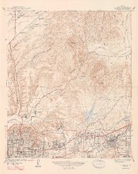
(5)- 1942 Map of La Mesa
 1942 La Mesa1942 Print · USGSSan Diego and La Mesa appear here in the early 1940s, showing a landscape of growing residential neighborhoods and rugged canyon terrain. Genealogists and historians can trace numerous early schools like Hoover High Sch, the grounds of State College, and the historic Mission San Diego.
 - 1942 Map of El Cajon
 1942 El Cajon1942 Print · USGSInland San Diego County unfolds in the early 1940s, showing a landscape of working ranches and river valleys before modern development. Genealogists and historians can trace family-named lands like Peale Ranch and early institutions such as Dehesa Sch and the Daky Mine.
 - 1944 Map of National City
 1944 National City1944 Print · USGSPost-war San Diego County comes alive in this survey of the South Bay and its inland valleys. Genealogists and historians can trace family plots at Holy Cross Cem, the growth of Lincoln Acres, or the operations of the Chollas Heights Naval Radio Sta.
 - 1947 Map of La Mesa
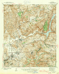
 1947 La Mesa1947 Print · USGSSan Diego's eastern suburbs were rapidly expanding in the late 1930s and 1940s as residential blocks pushed toward the foothills. Trace the early development of Normal Hts and State College alongside landmarks like the Murray Reservoir and Grantville.2 unique versions available
 - 1947 Map of El Cajon
 1947 El Cajon1947 Print · USGSThe San Diego River valley and its surrounding foothills appear in the late thirties, centered on the growing community of El Cajon. Genealogists and historians can trace family holdings like Fanita Ranch or locate the Indian Cem and Dehesa Sch in the southern hills.
End of results
Showing maps 1-5 of 5
Top cities near La Mesa
- San Diego historical maps
- Chula Vista historical maps
- El Cajon historical maps
- Santee historical maps
- National City historical maps
- Poway historical maps
See more
Frequently asked questions
- What are the different types of historical maps available for La Mesa?
- What is the oldest map of La Mesa?
- Where can I purchase historical maps of La Mesa for my home or office?
- Where can I download high-res historical maps of La Mesa?
- Are there historical topographic maps available for La Mesa?
- Is there historical aerial imagery available for La Mesa?
- Where are historical maps of La Mesa sourced from?