1960s Maps of La Mesa, California
Explore 3 historic maps of La Mesa from the 1960s. These maps offer a rare glimpse into what life looked like during the 1960s — showing old roads, neighborhoods, homes, and landmarks that have changed or disappeared over time.
Whether you're researching your family's past, planning a metal detecting trip, or studying how La Mesa's landscape evolved across the 1960s, these high-resolution maps are a powerful tool for exploring the history of this region.
- Focus on a specific era: All maps on this page are from the 1960s, giving you a focused view of this time period.
- See what’s changed: Compare century-old streets, trails, and buildings to today's modern landscape using overlays and satellite layers.
- Research with precision: Use these maps for genealogy, historical research, land use analysis, or educational projects.
- View, download, or print: Maps are fully viewable online in high resolution, and can be downloaded or printed for your own records.
Start exploring La Mesa's history through authentic maps from the 1960s. This is your window into the past.
La Mesa, CA maps
(3)- 1967 Map of El Cajon, 1969 Print
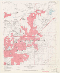 1967 El Cajon1969 Print · USGSEl Cajon and Santee are shown here during a period of rapid mid-century suburban expansion across the San Diego River valley. Researchers can trace the development of local landmarks like Gillespie Field, the El Cajon Cem, and Edgemoor Hospital.7 unique versions available
 - 1967 Map of La Mesa, 1969 Print
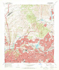 1967 La Mesa1969 Print · USGSSan Diego and La Mesa expand rapidly into the canyons and mesas during the late sixties. Genealogists and historians can locate dozens of neighborhood schools, the newly built San Diego Stadium, and the historic Mission San Diego de Alcala.4 unique versions available
 - 1967 Map of National City, 1970 Print
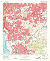 1967 National City1970 Print · USGSThe South Bay region of San Diego undergoes rapid suburbanization in the late sixties as new freeways bridge the coastal mesas. Genealogists and historians can trace the development of Lincoln Acres and Chula Vista or locate landmarks like La Vista Cem and the Naval Radio Sta.3 unique versions available
End of results
Showing maps 1-3 of 3
Top cities near La Mesa
- San Diego historical maps
- Chula Vista historical maps
- El Cajon historical maps
- Santee historical maps
- National City historical maps
- Poway historical maps
See more
Frequently asked questions
- What are the different types of historical maps available for La Mesa?
- What is the oldest map of La Mesa?
- Where can I purchase historical maps of La Mesa for my home or office?
- Where can I download high-res historical maps of La Mesa?
- Are there historical topographic maps available for La Mesa?
- Is there historical aerial imagery available for La Mesa?
- Where are historical maps of La Mesa sourced from?