1910s Maps of Lathrop, California
Explore 2 historic maps of Lathrop from the 1910s. These maps offer a rare glimpse into what life looked like during the 1910s — showing old roads, neighborhoods, homes, and landmarks that have changed or disappeared over time.
Whether you're researching your family's past, planning a metal detecting trip, or studying how Lathrop's landscape evolved across the 1910s, these high-resolution maps are a powerful tool for exploring the history of this region.
- Focus on a specific era: All maps on this page are from the 1910s, giving you a focused view of this time period.
- See what’s changed: Compare century-old streets, trails, and buildings to today's modern landscape using overlays and satellite layers.
- Research with precision: Use these maps for genealogy, historical research, land use analysis, or educational projects.
- View, download, or print: Maps are fully viewable online in high resolution, and can be downloaded or printed for your own records.
Start exploring Lathrop's history through authentic maps from the 1910s. This is your window into the past.
Lathrop, CA maps
(2)- 1914 Map of Union Island
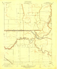 1914 Union Island1914 Print · USGSThe San Joaquin Delta was a maze of reclaiming lands and new canals in the years before the Great War. Researchers can trace the early infrastructure of Union Island and find rural landmarks like the Naglee School and the Southern Pacific line.2 unique versions available
 - 1915 Map of Lathrop
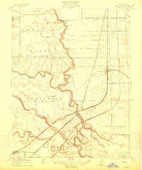 1915 Lathrop1915 Print · USGSSan Joaquin County at the height of the railroad era reveals a complex delta landscape of river bends and major rail junctions. Researchers can trace the early footprints of Lathrop and Banta or locate vanished rural schoolhouses like Island School and Mossdale School.2 unique versions available
End of results
Showing maps 1-2 of 2
Top cities near Lathrop
- Stockton historical maps
- Tracy historical maps
- Manteca historical maps
- Mountain House historical maps
- Ripon historical maps
Top neighborhoods of Lathrop
Frequently asked questions
- What are the different types of historical maps available for Lathrop?
- What is the oldest map of Lathrop?
- Where can I purchase historical maps of Lathrop for my home or office?
- Where can I download high-res historical maps of Lathrop?
- Are there historical topographic maps available for Lathrop?
- Is there historical aerial imagery available for Lathrop?
- Where are historical maps of Lathrop sourced from?