1900s (20th Century) Maps of Cambria, California
Explore 11 historic maps of Cambria from the 1900s (20th Century). These maps offer a rare glimpse into what life looked like during the 1900s — showing old roads, neighborhoods, homes, and landmarks that have changed or disappeared over time.
Whether you're researching your family's past, planning a metal detecting trip, or studying how Cambria's landscape evolved across the 1900s, these high-resolution maps are a powerful tool for exploring the history of this region.
- Focus on a specific era: All maps on this page are from the 1900s, giving you a focused view of this time period.
- See what’s changed: Compare century-old streets, trails, and buildings to today's modern landscape using overlays and satellite layers.
- Research with precision: Use these maps for genealogy, historical research, land use analysis, or educational projects.
- View, download, or print: Maps are fully viewable online in high resolution, and can be downloaded or printed for your own records.
Start exploring Cambria's history through authentic maps from the 1900s. This is your window into the past.
Cambria, CA maps
(11)- 1919 Map of San Simeon
 1919 San Simeon1919 Print · USGSThe San Luis Obispo coast during the late 1910s reveals a landscape of cattle ranches, early maritime landings, and upland mining. Genealogists and historians can trace family-named sites like the Hearst Ranch, Old Castro House, and the Olmstead School.4 unique versions available
 - 1937 Map of San Simeon, 1942 Print
 1937 San Simeon1942 Print · USGSThe Central California coast appears here in the late 1930s, showing the early infrastructure surrounding the iconic Hearst Castle and Hearst Ranch. Genealogists and historians can trace family locations at the Old Castro House, the Cambria Mine, and rural institutions like the Santa Rosa School.
 - 1947 Map of San Luis Obispo, 1948 Print
 1947 San Luis Obispo1948 Print · USGSCoastal California at the dawn of the Cold War reveals a landscape of massive military reservations and quiet seaside towns. Genealogists and researchers can trace the Southern Pacific rail line, old mining sites like Los Burros Mine, and local landmarks from Point Buchon to the Carrizo Plain.
 - 1948 Map of San Luis Obispo
 1948 San Luis Obispo1948 Print · USGSCentral Coast life in the late 1940s is centered on the Southern Pacific rail line and expanding military bases. Genealogists can trace early rural life through Union School and local operations like the Klau Mine or Buena Vista Mine.
 - 1956 Map of San Luis Obispo, 1963 Print
 1956 San Luis Obispo1963 Print · USGSCentral California coastal and valley life unfolds in the mid-fifties, from the shoreline of Pismo Beach to the arid Carrizo Plain. Trace early travel routes along the Southern Pacific RR or locate family sites near the Templeton Cemetery and Paso Robles County Cemetery.5 unique versions available
 - 1957 Map of San Luis Obispo
 1957 San Luis Obispo1957 Print · USGSCoastal California in the late fifties is defined by the steep Santa Lucia Range and the rail-connected hub of San Luis Obispo. Genealogists and researchers can trace rural life via Union School, the Southern Pacific line, and old sites like the Polar Star Mine.
 - 1958 Map of San Luis Obispo
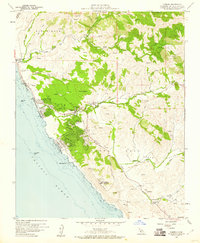
 1958 San Luis Obispo1958 Print · USGSThe Central Coast in the late fifties reveals a landscape of ranching and early tourism before the massive expansion of the modern era. Trace the path of the Southern Pacific through Atascadero or locate family roots in coastal towns like Cayucos and Cambria.
 - 1959 Map of Pico Creek, 1960 Print
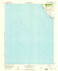 1959 Pico Creek1960 Print · USGSCoastal San Luis Obispo County is captured here in the late fifties as residential streets began to branch off the Pacific coast. Genealogists and local historians can trace early neighborhood footprints at The Oaks and the boundaries of the Piedra Blanca Grant.4 unique versions available
 - 1959 Map of Cambria, 1960 Print
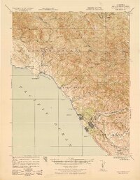
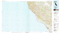
 1959 Cambria1960 Print · USGSCoastal San Luis Obispo County is captured here in the late fifties, showing the transition from seaside village life to upland ranching. You can trace the residential growth of Cambria and locate historic sites like the Santa Rosa Cemetery and the Cambria Air Force Station.4 unique versions available
 - 1959 Map of San Simeon, 1961 Print
 1959 San Simeon1961 Print · USGSThe Central Coast of California in the late fifties is defined by the grand estates of the Santa Lucia Range and a developing shoreline. Researchers can trace the grounds of Hearst Castle, locate the Buckeye Mine, and explore the village of Cambria.2 unique versions available
 - 1980 Map of Cambria
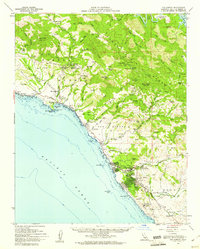
 1980 Cambria1980 Print · USGSThe Central Coast in the early eighties shows a landscape of grand estates and isolated seaside outposts. Trace family roots and local history through the coastal village of Cambria, the Hearst Castle grounds, and the historic Lighthouse at Piedras Blancas.2 unique versions available
End of results
Showing maps 1-11 of 11
Top cities near Cambria
Top neighborhoods of Cambria
- Marine Terrace historical maps
- Lodge Hill historical maps
- West Village historical maps
- Happy Hill historical maps
- Leimert historical maps
- Tin City historical maps
See more
Frequently asked questions
- What are the different types of historical maps available for Cambria?
- What is the oldest map of Cambria?
- Where can I purchase historical maps of Cambria for my home or office?
- Where can I download high-res historical maps of Cambria?
- Are there historical topographic maps available for Cambria?
- Is there historical aerial imagery available for Cambria?
- Where are historical maps of Cambria sourced from?