Old Maps of La Panza, California for Academic Research
Study the evolution of La Panza with 16 high-resolution historic maps. Whether you're teaching, researching, or modeling changes in land use, these maps provide essential visual documentation of urban, environmental, and geographic change.
- Analyze long-term change: Track patterns in development, transportation, and natural features.
- Ideal for environmental or urban studies: Support academic projects with primary historical map data.
- Use in the classroom or lab: Educators and researchers rely on these maps to bring historical context to life.
These maps are a powerful tool for teaching, research, and visualizing how La Panza has changed over the decades.
La Panza, CA maps
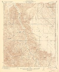
(16)- 1932 Map of La Panza
 1932 La Panza1932 Print · USGSSan Luis Obispo County ranch lands meet the high desert during the early 1930s. Genealogists and local historians can trace family-named outposts like La Panza Ranch, the waters of Carnaza Spr, and the remote French Camp.
 - 1935 Map of La Panza
 1935 La Panza1935 Print · USGSThe San Luis Obispo backcountry comes into focus during the mid-thirties, showing the rugged ranch lands between the mountains and the desert flats. Researchers can trace historic creek-side settlements like La Panza or locate water sources such as Mustang Spr and Carriaza Spr.
 - 1936 Map of La Panza
 1936 La Panza1936 Print · USGSThe ranching and mining country of eastern San Luis Obispo County is captured here in the mid-1930s. Genealogists and researchers can trace family lands near La Panza Ranch, locate the camp at French Camp, or follow the course of Placer Creek.3 unique versions available
 - 1947 Map of San Luis Obispo, 1948 Print
 1947 San Luis Obispo1948 Print · USGSCoastal California at the dawn of the Cold War reveals a landscape of massive military reservations and quiet seaside towns. Genealogists and researchers can trace the Southern Pacific rail line, old mining sites like Los Burros Mine, and local landmarks from Point Buchon to the Carrizo Plain.
 - 1948 Map of San Luis Obispo
 1948 San Luis Obispo1948 Print · USGSCentral Coast life in the late 1940s is centered on the Southern Pacific rail line and expanding military bases. Genealogists can trace early rural life through Union School and local operations like the Klau Mine or Buena Vista Mine.
 - 1952 Map of La Panza, 1953 Print
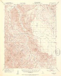 1952 La Panza1953 Print · USGSThe high desert of eastern San Luis Obispo County is shown here in the early fifties during a period of ranching and early oil exploration. Genealogists and historians can locate remote outposts like La Panza Ranch, the Queen Bee Camp Ground, and topographic landmarks like Syncline Hill.3 unique versions available
 - 1956 Map of San Luis Obispo, 1963 Print
 1956 San Luis Obispo1963 Print · USGSCentral California coastal and valley life unfolds in the mid-fifties, from the shoreline of Pismo Beach to the arid Carrizo Plain. Trace early travel routes along the Southern Pacific RR or locate family sites near the Templeton Cemetery and Paso Robles County Cemetery.5 unique versions available
 - 1957 Map of San Luis Obispo
 1957 San Luis Obispo1957 Print · USGSCoastal California in the late fifties is defined by the steep Santa Lucia Range and the rail-connected hub of San Luis Obispo. Genealogists and researchers can trace rural life via Union School, the Southern Pacific line, and old sites like the Polar Star Mine.
 - 1958 Map of San Luis Obispo
 1958 San Luis Obispo1958 Print · USGSThe Central Coast in the late fifties reveals a landscape of ranching and early tourism before the massive expansion of the modern era. Trace the path of the Southern Pacific through Atascadero or locate family roots in coastal towns like Cayucos and Cambria.
 - 1967 Map of La Panza, 1968 Print
 1967 La Panza1968 Print · USGSThe backcountry of San Luis Obispo County is captured here in the mid-1960s, showing a landscape defined by springs and pack trails. Researchers can locate remote outposts like Saylors Cabin and Martinez Place near the heights of Machesna Mountain.2 unique versions available
 - 1981 Map of San Luis Obispo
 1981 San Luis Obispo1981 Print · USGSThe Central Coast comes alive in the early eighties as the Southern Pacific railroad connects growing coastal towns and rugged inland ranges. Researchers can trace land grants like Santa Manuela, locate Cem sites, and explore the footprint of California Polytechnic State University.3 unique versions available
 - 1995 Map of La Panza, 2000 Print
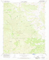
 1995 La Panza2000 Print · USGSThe high backcountry of San Luis Obispo County is captured here in the mid-1990s as it transitions from ranching lands to protected wilderness. Genealogists and hikers can trace old family sites like Martinez Place and remote landmarks including Coyote Hole and King David Spring.
 - 2012 Map of La Panza, 2012 Print
 2012 La Panza2012 Print · USGSCovers La Panza, including San Luis Obispo County, United States, and other nearby areas
 - 2015 Map of La Panza, 2015 Print
 2015 La Panza2015 Print · USGSCovers La Panza, including San Luis Obispo County, United States, and other nearby areas
 - 2018 Map of La Panza, 2018 Print
 2018 La Panza2018 Print · USGSCovers La Panza, including San Luis Obispo County, United States, and other nearby areas
 - 2021 Map of La Panza, 2021 Print
 2021 La Panza2021 Print · USGSSan Luis Obispo County’s interior highlands come into focus in this recent survey of the backcountry around the historic La Panza settlement. Trace the drainages of San Juan Cr or locate named landmarks like Machesna Potrero and King David Spring.
End of results
Showing maps 1-16 of 16
Frequently asked questions
- What are the different types of historical maps available for La Panza?
- What is the oldest map of La Panza?
- Where can I purchase historical maps of La Panza for my home or office?
- Where can I download high-res historical maps of La Panza?
- Are there historical topographic maps available for La Panza?
- Is there historical aerial imagery available for La Panza?
- Where are historical maps of La Panza sourced from?