Old Maps of Pippin Corner, California for Academic Research
Study the evolution of Pippin Corner with 14 high-resolution historic maps. Whether you're teaching, researching, or modeling changes in land use, these maps provide essential visual documentation of urban, environmental, and geographic change.
- Analyze long-term change: Track patterns in development, transportation, and natural features.
- Ideal for environmental or urban studies: Support academic projects with primary historical map data.
- Use in the classroom or lab: Educators and researchers rely on these maps to bring historical context to life.
These maps are a powerful tool for teaching, research, and visualizing how Pippin Corner has changed over the decades.
Pippin Corner, CA maps
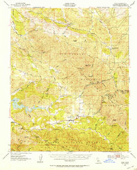
(14)- 1922 Map of Pozo
 1922 Pozo1922 Print · USGSSan Luis Obispo County backcountry reveals its rural school network and forest boundaries in the years following the Great War. Genealogists and local historians can trace the locations of the El Dorado School and Highland School near the settlement of Pozo.3 unique versions available
 - 1947 Map of San Luis Obispo, 1948 Print
 1947 San Luis Obispo1948 Print · USGSCoastal California at the dawn of the Cold War reveals a landscape of massive military reservations and quiet seaside towns. Genealogists and researchers can trace the Southern Pacific rail line, old mining sites like Los Burros Mine, and local landmarks from Point Buchon to the Carrizo Plain.
 - 1948 Map of San Luis Obispo
 1948 San Luis Obispo1948 Print · USGSCentral Coast life in the late 1940s is centered on the Southern Pacific rail line and expanding military bases. Genealogists can trace early rural life through Union School and local operations like the Klau Mine or Buena Vista Mine.
 - 1952 Map of Pozo, 1954 Print
 1952 Pozo1954 Print · USGSSan Luis Obispo County ranching and mountain country are frozen in time here during the early fifties. Local historians can trace the network of old roads and mines like the Red Eagle Mine or locate early centers of community like Pozo and the Pozo Sch.3 unique versions available
 - 1956 Map of San Luis Obispo, 1963 Print
 1956 San Luis Obispo1963 Print · USGSCentral California coastal and valley life unfolds in the mid-fifties, from the shoreline of Pismo Beach to the arid Carrizo Plain. Trace early travel routes along the Southern Pacific RR or locate family sites near the Templeton Cemetery and Paso Robles County Cemetery.5 unique versions available
 - 1957 Map of San Luis Obispo
 1957 San Luis Obispo1957 Print · USGSCoastal California in the late fifties is defined by the steep Santa Lucia Range and the rail-connected hub of San Luis Obispo. Genealogists and researchers can trace rural life via Union School, the Southern Pacific line, and old sites like the Polar Star Mine.
 - 1958 Map of San Luis Obispo
 1958 San Luis Obispo1958 Print · USGSThe Central Coast in the late fifties reveals a landscape of ranching and early tourism before the massive expansion of the modern era. Trace the path of the Southern Pacific through Atascadero or locate family roots in coastal towns like Cayucos and Cambria.
 - 1967 Map of Santa Margarita Lake, 1969 Print
 1967 Santa Margarita Lake1969 Print · USGSSan Luis Obispo County in the mid-sixties reveals a landscape of new recreation and old industry. Genealogists and historians can locate the Rinconada Mine, the settlement of Pozo, and numerous backcountry springs like McNeil Spring.3 unique versions available
 - 1981 Map of San Luis Obispo
 1981 San Luis Obispo1981 Print · USGSThe Central Coast comes alive in the early eighties as the Southern Pacific railroad connects growing coastal towns and rugged inland ranges. Researchers can trace land grants like Santa Manuela, locate Cem sites, and explore the footprint of California Polytechnic State University.3 unique versions available
 - 1995 Map of Santa Margarita Lake, 2000 Print
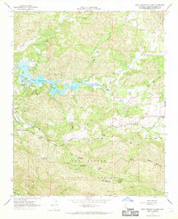
 1995 Santa Margarita Lake2000 Print · USGSThe coastal hills of San Luis Obispo County are mapped here in the mid-1990s, during a period of transition between historic mining and wilderness preservation. Trace the area's mercury mining history at Rinconada Mine, locate the junction at Pippin Corner, and explore the canyon lands near Pozo.
 - 2012 Map of Santa Margarita Lake, 2012 Print
 2012 Santa Margarita Lake2012 Print · USGSCovers Pippin Corner, including Pozo, San Luis Obispo County, and other nearby areas
 - 2015 Map of Santa Margarita Lake, 2015 Print
 2015 Santa Margarita Lake2015 Print · USGSCovers Pippin Corner, including Pozo, San Luis Obispo County, and other nearby areas
 - 2018 Map of Santa Margarita Lake, 2018 Print
 2018 Santa Margarita Lake2018 Print · USGSCovers Pippin Corner, including Pozo, San Luis Obispo County, and other nearby areas
 - 2021 Map of Santa Margarita Lake, 2021 Print
 2021 Santa Margarita Lake2021 Print · USGSThe southern Salinas River watershed and the rugged interior of San Luis Obispo County are mapped here in the early twenty-first century. Researchers can trace historic access routes and water sources like the Rinconada Trl, the settlement of Pozo, and Hi Mountain Spring.
End of results
Showing maps 1-14 of 14
Top cities near Pippin Corner
- San Luis Obispo historical maps
- Atascadero historical maps
- Arroyo Grande historical maps
- Grover Beach historical maps
- Pismo Beach historical maps
- Oceano historical maps
Frequently asked questions
- What are the different types of historical maps available for Pippin Corner?
- What is the oldest map of Pippin Corner?
- Where can I purchase historical maps of Pippin Corner for my home or office?
- Where can I download high-res historical maps of Pippin Corner?
- Are there historical topographic maps available for Pippin Corner?
- Is there historical aerial imagery available for Pippin Corner?
- Where are historical maps of Pippin Corner sourced from?