1940s Maps of Tangair, California
Explore 5 historic maps of Tangair from the 1940s. These maps offer a rare glimpse into what life looked like during the 1940s — showing old roads, neighborhoods, homes, and landmarks that have changed or disappeared over time.
Whether you're researching your family's past, planning a metal detecting trip, or studying how Tangair's landscape evolved across the 1940s, these high-resolution maps are a powerful tool for exploring the history of this region.
- Focus on a specific era: All maps on this page are from the 1940s, giving you a focused view of this time period.
- See what’s changed: Compare century-old streets, trails, and buildings to today's modern landscape using overlays and satellite layers.
- Research with precision: Use these maps for genealogy, historical research, land use analysis, or educational projects.
- View, download, or print: Maps are fully viewable online in high resolution, and can be downloaded or printed for your own records.
Start exploring Tangair's history through authentic maps from the 1940s. This is your window into the past.
Tangair, CA maps
(5)- 1942 Map of Guadalupe
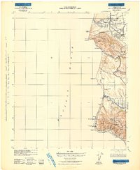 1942 Guadalupe1942 Print · USGSThe Central Coast during the early war years reveals a landscape of coastal rail stations and ranching canyons along the Santa Barbara shore. Researchers can trace the Southern Pacific line through Surf and Honda to find vanished spurs and schools like Lynden Sch.
 - 1942 Map of Point Sal
 1942 Point Sal1942 Print · USGSThe Santa Barbara coast during the early war years is shown here in high detail, from the river valley down to the Pacific cliffs. Genealogists and researchers can trace the rail settlements at Narlon, the rural community at Casmalia, and the local Bonita Sch.
 - 1947 Map of Casmalia
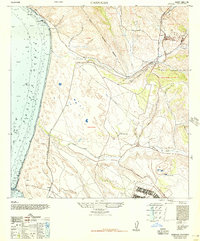 1947 Casmalia1947 Print · USGSThe Santa Barbara coast at the end of the 1940s reveals a landscape of sprawling ranches and military holdings. Trace the coastal rail line through Schumann, the grounds of Marshallia Ranch, and the winding San Antonio Creek.2 unique versions available
 - 1947 Map of Point Sal, 1957 Print
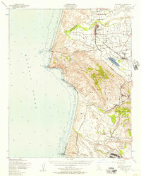 1947 Point Sal1957 Print · USGSCoastal Santa Barbara County is captured here in the late 1940s, a period of transition between wartime activity and post-war growth. Genealogists and historians can trace the rail-side life of Guadalupe, the agricultural roots of Betteravia, and the early footprint of Camp Cooke.2 unique versions available
 - 1948 Map of Santa Maria
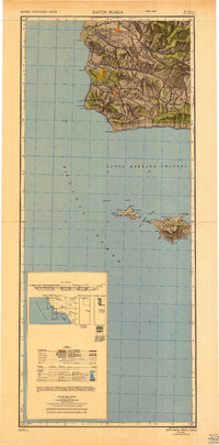 1948 Santa Maria1948 Print · USGSSanta Barbara County in the late 1940s reveals a landscape of coastal defense and valley agriculture. Genealogists and historians can trace the footprint of Camp Cooke Military Reservation or locate rural landmarks like Honda School and Betteravia.2 unique versions available
End of results
Showing maps 1-5 of 5
Top cities near Tangair
- Santa Maria historical maps
- Lompoc historical maps
- Lompoc historical maps
- Orcutt historical maps
- Vandenberg Village historical maps
- Guadalupe historical maps
See more
Frequently asked questions
- What are the different types of historical maps available for Tangair?
- What is the oldest map of Tangair?
- Where can I purchase historical maps of Tangair for my home or office?
- Where can I download high-res historical maps of Tangair?
- Are there historical topographic maps available for Tangair?
- Is there historical aerial imagery available for Tangair?
- Where are historical maps of Tangair sourced from?