Old Maps of Gilroy, California
Explore 26 old maps of Gilroy, spanning from 1915 to today. These high-resolution historic maps reveal how streets, neighborhoods, landmarks, and natural features evolved over time — perfect for genealogy, metal detecting, research, and local history exploration.
What you can do with these maps:
- See how Gilroy changed over time: Compare historical maps to modern-day views to trace roads, homesites, rail lines & more.
- View detailed metadata: Each map includes creators, publishers, year, scale, and archive source.
- Overlay maps with satellite & LiDAR: Visualize the past alongside modern tools to explore terrain & human change.
- Trusted historical sources: Maps sourced from the USGS, Library of Congress, and other archives.
- Access maps your way: View online, download high-res files, or order prints for personal or research use.
Start exploring old maps of Gilroy to uncover forgotten places, hidden landmarks, and the deep history beneath your feet.
Gilroy, CA maps
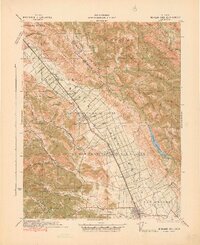
(26)- 1915 Map of San Juan Bautista
 1915 San Juan Bautista1915 Print · USGSCovers Gilroy, including Watsonville, Prunedale, and other nearby areas
 - 1917 Map of Morgan Hill
 1917 Morgan Hill1917 Print · USGSCovers Gilroy, including San Jose, Morgan Hill, and other nearby areas5 unique versions available
 - 1917 Map of San Juan Bautista
 1917 San Juan Bautista1917 Print · USGSCovers Gilroy, including Watsonville, Prunedale, and other nearby areas8 unique versions available
 - 1939 Map of Morgan Hill, 1957 Print
 1939 Morgan Hill1957 Print · USGSCovers Gilroy, including San Jose, Morgan Hill, and other nearby areas2 unique versions available
 - 1939 Map of San Juan Bautista, 1958 Print
 1939 San Juan Bautista1958 Print · USGSCovers Gilroy, including Watsonville, Prunedale, and other nearby areas2 unique versions available
 - 1940 Map of San Juan Bautista
 1940 San Juan Bautista1940 Print · USGSCovers Gilroy, including Watsonville, Prunedale, and other nearby areas
 - 1941 Map of Morgan Hill
 1941 Morgan Hill1941 Print · USGSCovers Gilroy, including San Jose, Morgan Hill, and other nearby areas
 - 1947 Map of San Jose, 1948 Print
 1947 San Jose1948 Print · USGSCovers Gilroy, including San Jose, Stockton, and other nearby areas
 - 1948 Map of Santa Cruz
 1948 Santa Cruz1948 Print · USGSCovers Gilroy, including Salinas, Madera, and other nearby areas2 unique versions available
 - 1955 Map of Santa Cruz
 1955 Santa Cruz1955 Print · USGSCovers Gilroy, including Salinas, Madera, and other nearby areas
 - 1955 Map of Chittenden, 1956 Print
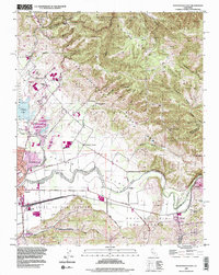
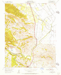 1955 Chittenden1956 Print · USGSCovers Gilroy, including Old Gilroy, Carnadero, and other nearby areas10 unique versions available
 - 1955 Map of Mt. Madonna, 1956 Print
 1955 Mt. Madonna1956 Print · USGSCovers Gilroy, including Morgan Hill, Redwood Retreat, and other nearby areas6 unique versions available
 - 1955 Map of Watsonville East, 1956 Print
 1955 Watsonville East1956 Print · USGSCovers Gilroy, including Watsonville, Pajaro, and other nearby areas6 unique versions available
 - 1955 Map of Gilroy, 1956 Print
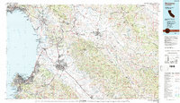
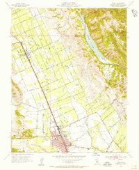 1955 Gilroy1956 Print · USGSCovers Gilroy, including Morgan Hill, Rucker, and other nearby areas7 unique versions available
 - 1956 Map of San Jose
 1956 San Jose1956 Print · USGSCovers Gilroy, including San Jose, Stockton, and other nearby areas
 - 1957 Map of Santa Cruz
 1957 Santa Cruz1957 Print · USGSCovers Gilroy, including Salinas, Madera, and other nearby areas
 - 1958 Map of Santa Cruz
 1958 Santa Cruz1958 Print · USGSCovers Gilroy, including Salinas, Madera, and other nearby areas2 unique versions available
 - 1962 Map of San Jose
 1962 San Jose1962 Print · USGSCovers Gilroy, including San Jose, Stockton, and other nearby areas4 unique versions available
 - 1965 Map of Santa Cruz, 1968 Print
 1965 Santa Cruz1968 Print · USGSCovers Gilroy, including Salinas, Madera, and other nearby areas
 - 1966 Map of San Jose
 1966 San Jose1966 Print · USGSCovers Gilroy, including San Jose, Stockton, and other nearby areas
 - 1973 Map of Gilroy, 1979 Print
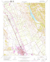 1973 Gilroy1979 Print · USGSCovers Gilroy, including Morgan Hill, Rucker, and other nearby areas
 - 1974 Map of Monterey, 1977 Print
 1974 Monterey1977 Print · USGSCovers Gilroy, including Salinas, Madera, and other nearby areas
 - 1978 Map of San Jose
 1978 San Jose1978 Print · USGSCovers Gilroy, including San Jose, Fremont, and other nearby areas
 - 1983 Map of Monterey, 1984 Print
 1983 Monterey1984 Print · USGSCovers Gilroy, including Salinas, Santa Cruz, and other nearby areas2 unique versions available
 - 1995 Map of Watsonville East, 1998 Print
 1995 Watsonville East1998 Print · USGSCovers Gilroy, including Watsonville, Pajaro, and other nearby areas2 unique versions available
Showing maps 1-25 of 26
Top cities near Gilroy
- San Jose historical maps
- Watsonville historical maps
- Morgan Hill historical maps
- Hollister historical maps
- Prunedale historical maps
- Pajaro historical maps
See more
Top neighborhoods of Gilroy
Frequently asked questions
- What are the different types of historical maps available for Gilroy?
- What is the oldest map of Gilroy?
- Where can I purchase historical maps of Gilroy for my home or office?
- Where can I download high-res historical maps of Gilroy?
- Are there historical topographic maps available for Gilroy?
- Is there historical aerial imagery available for Gilroy?
- Where are historical maps of Gilroy sourced from?