1940s Maps of Gilroy, California
Explore 4 historic maps of Gilroy from the 1940s. These maps offer a rare glimpse into what life looked like during the 1940s — showing old roads, neighborhoods, homes, and landmarks that have changed or disappeared over time.
Whether you're researching your family's past, planning a metal detecting trip, or studying how Gilroy's landscape evolved across the 1940s, these high-resolution maps are a powerful tool for exploring the history of this region.
- Focus on a specific era: All maps on this page are from the 1940s, giving you a focused view of this time period.
- See what’s changed: Compare century-old streets, trails, and buildings to today's modern landscape using overlays and satellite layers.
- Research with precision: Use these maps for genealogy, historical research, land use analysis, or educational projects.
- View, download, or print: Maps are fully viewable online in high resolution, and can be downloaded or printed for your own records.
Start exploring Gilroy's history through authentic maps from the 1940s. This is your window into the past.
Gilroy, CA maps
(4)- 1940 Map of San Juan Bautista
 1940 San Juan Bautista1940 Print · USGSCentral California coastal and valley life at the start of the 1940s is captured here, where four counties meet. Genealogy researchers can trace family-named sites like Patrick Breen, old rural institutions like the St Francis Orphan Asylum, and the early Sargent Oil Fields.
 - 1941 Map of Morgan Hill
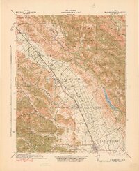 1941 Morgan Hill1941 Print · USGSThe Santa Clara Valley corridor comes alive in the early 1940s, showing a landscape of ranchos and rail-side towns. Trace family roots at Redwood School or find old landmarks like Bradley's Store and Madrone Soda Springs.
 - 1947 Map of San Jose, 1948 Print
 1947 San Jose1948 Print · USGSNorthern California's heartland is captured here just after the war, showing the rapid growth of the Santa Clara and Central Valleys. Researchers can trace the legacy of rail and water at Castle Air Force Base, Stockton, and the Hetch Hetchy Aqueduct.
 - 1948 Map of Santa Cruz
 1948 Santa Cruz1948 Print · USGSThe Central Coast and San Joaquin Valley meet in this mid-century look at the region's agricultural and military geography. Genealogists and historians can trace the paths of El Camino Real, locate family farms near Hollister, or study the footprint of the Fort Ord Military Reservation.2 unique versions available
End of results
Showing maps 1-4 of 4
Top cities near Gilroy
- San Jose historical maps
- Watsonville historical maps
- Morgan Hill historical maps
- Hollister historical maps
- Prunedale historical maps
- Pajaro historical maps
See more
Top neighborhoods of Gilroy
Frequently asked questions
- What are the different types of historical maps available for Gilroy?
- What is the oldest map of Gilroy?
- Where can I purchase historical maps of Gilroy for my home or office?
- Where can I download high-res historical maps of Gilroy?
- Are there historical topographic maps available for Gilroy?
- Is there historical aerial imagery available for Gilroy?
- Where are historical maps of Gilroy sourced from?