1990s Maps of Gilroy, California
Explore 2 historic maps of Gilroy from the 1990s. These maps offer a rare glimpse into what life looked like during the 1990s — showing old roads, neighborhoods, homes, and landmarks that have changed or disappeared over time.
Whether you're researching your family's past, planning a metal detecting trip, or studying how Gilroy's landscape evolved across the 1990s, these high-resolution maps are a powerful tool for exploring the history of this region.
- Focus on a specific era: All maps on this page are from the 1990s, giving you a focused view of this time period.
- See what’s changed: Compare century-old streets, trails, and buildings to today's modern landscape using overlays and satellite layers.
- Research with precision: Use these maps for genealogy, historical research, land use analysis, or educational projects.
- View, download, or print: Maps are fully viewable online in high resolution, and can be downloaded or printed for your own records.
Start exploring Gilroy's history through authentic maps from the 1990s. This is your window into the past.
Gilroy, CA maps
(2)- 1995 Map of Watsonville East, 1998 Print
 1995 Watsonville East1998 Print · USGSCoastal agriculture and mountainous terrain meet in the Pajaro Valley during the mid-nineties. Researchers can trace the Southern Pacific rail corridor through Watsonville Junction or locate family sites at Pajaro Valley Memorial Park and Johnston Corner.2 unique versions available
 - 1996 Map of Mount Madonna, 2000 Print
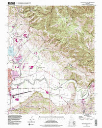
 1996 Mount Madonna2000 Print · USGSThe foothills of the Santa Cruz Mountains and the rising suburban edge of the Santa Clara Valley are shown here in the mid-1990s. Genealogists and local historians can trace the locations of the Machado School, Mt Hope Cem, and the historic Redwood Retreat.
End of results
Showing maps 1-2 of 2
Top cities near Gilroy
- San Jose historical maps
- Watsonville historical maps
- Morgan Hill historical maps
- Hollister historical maps
- Prunedale historical maps
- Pajaro historical maps
See more
Top neighborhoods of Gilroy
Frequently asked questions
- What are the different types of historical maps available for Gilroy?
- What is the oldest map of Gilroy?
- Where can I purchase historical maps of Gilroy for my home or office?
- Where can I download high-res historical maps of Gilroy?
- Are there historical topographic maps available for Gilroy?
- Is there historical aerial imagery available for Gilroy?
- Where are historical maps of Gilroy sourced from?