1950s Maps of Morgan Hill, California
Explore 5 historic maps of Morgan Hill from the 1950s. These maps offer a rare glimpse into what life looked like during the 1950s — showing old roads, neighborhoods, homes, and landmarks that have changed or disappeared over time.
Whether you're researching your family's past, planning a metal detecting trip, or studying how Morgan Hill's landscape evolved across the 1950s, these high-resolution maps are a powerful tool for exploring the history of this region.
- Focus on a specific era: All maps on this page are from the 1950s, giving you a focused view of this time period.
- See what’s changed: Compare century-old streets, trails, and buildings to today's modern landscape using overlays and satellite layers.
- Research with precision: Use these maps for genealogy, historical research, land use analysis, or educational projects.
- View, download, or print: Maps are fully viewable online in high resolution, and can be downloaded or printed for your own records.
Start exploring Morgan Hill's history through authentic maps from the 1950s. This is your window into the past.
Morgan Hill, CA maps
(5)- 1955 Map of Morgan Hill, 1956 Print
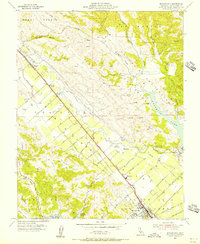 1955 Morgan Hill1956 Print · USGSThe Santa Clara Valley transitions from orchards to early suburban growth in the mid-fifties. Genealogists and historians can locate old district schools like Burnett Sch, the Wm F James Boys Ranch, and the rail stops at Madrone and South Coyote.6 unique versions available
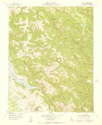
 - 1955 Map of Mt. Madonna, 1956 Print
 1955 Mt. Madonna1956 Print · USGSThe Santa Clara Valley and Santa Cruz Mountains meet in this mid-fifties study of growing towns and rugged parklands. Genealogists and local historians can trace the foundations of Morgan Hill, the secluded Redwood Retreat, and historic rural landmarks like Machado School.6 unique versions available
 - 1955 Map of Gilroy, 1956 Print
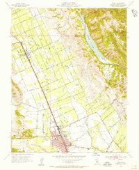 1955 Gilroy1956 Print · USGSThe Santa Clara Valley’s orchard and rail corridor are captured here during the mid-fifties, centered on the city of Gilroy. Genealogists and historians can trace early schools like Glen View Sch and San Ysidro Sch, alongside the tracks of the Southern Pacific.7 unique versions available
 - 1955 Map of Mt. Sizer, 1956 Print
 1955 Mt. Sizer1956 Print · USGSThe Santa Clara hills are shown mid-century, before the full development of the valley. Genealogists and researchers can trace ranching history at Los Huecos Ranch, locate the old Cochrane Bridge, or find the springs at Soda Springs.5 unique versions available
 - 1956 Map of San Jose
 1956 San Jose1956 Print · USGSCentral California in the mid-fifties reveals the transition from sprawling orchards to growing urban hubs like San Jose and Stockton. Genealogists and historians can trace the rail-era landscape of the Mother Lode through Chinese Camp and Tuttletown, or follow the water through the Joaquin River and Calaveras Reservoir.
End of results
Showing maps 1-5 of 5
Top cities near Morgan Hill
Top neighborhoods of Morgan Hill
Frequently asked questions
- What are the different types of historical maps available for Morgan Hill?
- What is the oldest map of Morgan Hill?
- Where can I purchase historical maps of Morgan Hill for my home or office?
- Where can I download high-res historical maps of Morgan Hill?
- Are there historical topographic maps available for Morgan Hill?
- Is there historical aerial imagery available for Morgan Hill?
- Where are historical maps of Morgan Hill sourced from?