1990s Maps of Paradise Park, California
Explore 2 historic maps of Paradise Park from the 1990s. These maps offer a rare glimpse into what life looked like during the 1990s — showing old roads, neighborhoods, homes, and landmarks that have changed or disappeared over time.
Whether you're researching your family's past, planning a metal detecting trip, or studying how Paradise Park's landscape evolved across the 1990s, these high-resolution maps are a powerful tool for exploring the history of this region.
- Focus on a specific era: All maps on this page are from the 1990s, giving you a focused view of this time period.
- See what’s changed: Compare century-old streets, trails, and buildings to today's modern landscape using overlays and satellite layers.
- Research with precision: Use these maps for genealogy, historical research, land use analysis, or educational projects.
- View, download, or print: Maps are fully viewable online in high resolution, and can be downloaded or printed for your own records.
Start exploring Paradise Park's history through authentic maps from the 1990s. This is your window into the past.
Paradise Park, CA maps
(2)- 1991 Map of Felton, 1995 Print
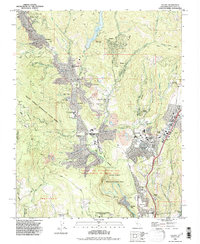 1991 Felton1995 Print · USGSThe Santa Cruz Mountains in the early nineties show a landscape defined by deep redwood canyons and growing mountain communities. Researchers can trace historic land use via the Zayante Old Railroad Grade, the Felton Covered Bridge, and the Open Pit Mine at Olympia.
 - 1998 Map of Felton, 2002 Print
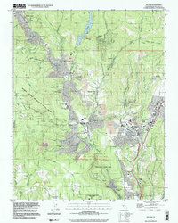 1998 Felton2002 Print · USGSThe San Lorenzo River valley in the late 1990s showcases a landscape of redwood forests and mountain settlements. Researchers can trace local history through sites like the Felton Covered Bridge, the Southern Pacific Railroad, and Mission Springs.
End of results
Showing maps 1-2 of 2
Top cities near Paradise Park
- San Jose historical maps
- Santa Cruz historical maps
- Watsonville historical maps
- Los Gatos historical maps
- Scotts Valley historical maps
- Capitola historical maps
See more
Frequently asked questions
- What are the different types of historical maps available for Paradise Park?
- What is the oldest map of Paradise Park?
- Where can I purchase historical maps of Paradise Park for my home or office?
- Where can I download high-res historical maps of Paradise Park?
- Are there historical topographic maps available for Paradise Park?
- Is there historical aerial imagery available for Paradise Park?
- Where are historical maps of Paradise Park sourced from?