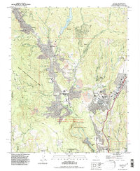
1991 Map of Felton
USGS Topo · Published 1995About this map
The San Lorenzo River winds through the Santa Cruz Mountains, anchoring a string of residential and recreational communities that define the region's mid-century character. This landscape is a dense mixture of protected forest and localized development, where Henry Cowell Redwoods State Park and the Bonny Doon Ecological Reserve sit adjacent to growing centers like Felton and Scotts Valley. Cultural landmarks such as the Felton Covered Bridge County Park and the conference grounds at Mount Hermon highlight the area's long-standing appeal as a mountain retreat.
Find a feature on this map
75 named features on this map. Tap any name to fly to it.
Don’t see what you’re looking for? This feature index may not catch every label — zoom into the map to look around manually.
Map Details
Editions of this 1991 Felton Map
This is the sole edition of this map. No revisions or reprints were ever made.
Other maps of this area

1902 · Santa Cruz
USGS Topo · 1:125,000

1912 · Capitola
USGS Topo · 1:62,500

1914 · Capitola
USGS Topo · 1:62,500

1916 · New Almaden
USGS Topo · 1:48,000

1919 · New Almaden
USGS Topo · 1:62,500
1940 · Capitola
USGS Topo · 1:62,500

1940 · Los Gatos
USGS Topo · 1:62,500

1943 · Los Gatos
USGS Topo · 1:62,500

1947 · San Francisco
USGS Topo · 1:250,000

1947 · San Jose
USGS Topo · 1:250,000