1940 Map of Capitola
USGS Topo · Published 1940About this map
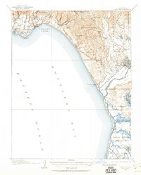
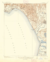
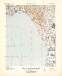
Watsonville and its surrounding sloughs anchor this coastal survey, reflecting a landscape defined by both maritime access and agricultural development on the eve of World War II. The Southern Pacific railroad threads together the beachfront communities of Capitola, Aptos, and Robroy, while the military presence at Camp McQuaide stands as a tactical landmark along the Monterey Bay shoreline. This 1940 tactical map reveals the transition from open ranchos like Bolsa Nueva y Moro Cojo to early aviation infrastructure, such as the Santa Cruz Airport and the Watsonville Airport. The interior is marked by numerous country schools, including Oakdale School and Larkin Valley School, which served the rural families living among the creek gulches and the timbered hills of the Shoquel Augmentation. The intricate network of wetlands, from Elkhorn Slough to Harkins Slough, highlights the complex hydrology that influenced the region's transport and land use.
Find a feature on this map
72 named features on this map. Tap any name to fly to it.
Don’t see what you’re looking for? This feature index may not catch every label — zoom into the map to look around manually.
Map Details
Editions of this 1940 Capitola Map
This is the sole edition of this map. No revisions or reprints were ever made.
Historical Maps of Santa Cruz Through Time
3 maps found