1900s (20th Century) Maps of Delta, California
Explore 8 historic maps of Delta from the 1900s (20th Century). These maps offer a rare glimpse into what life looked like during the 1900s — showing old roads, neighborhoods, homes, and landmarks that have changed or disappeared over time.
Whether you're researching your family's past, planning a metal detecting trip, or studying how Delta's landscape evolved across the 1900s, these high-resolution maps are a powerful tool for exploring the history of this region.
- Focus on a specific era: All maps on this page are from the 1900s, giving you a focused view of this time period.
- See what’s changed: Compare century-old streets, trails, and buildings to today's modern landscape using overlays and satellite layers.
- Research with precision: Use these maps for genealogy, historical research, land use analysis, or educational projects.
- View, download, or print: Maps are fully viewable online in high resolution, and can be downloaded or printed for your own records.
Start exploring Delta's history through authentic maps from the 1900s. This is your window into the past.
Delta, CA maps
(8)- 1901 Map of Redding
 1901 Redding1901 Print · USGSShasta County's northern canyon and mining districts come into focus at the dawn of the twentieth century. Researchers can trace the original rail stops at Kennett and Keswick or locate early industrial sites like the Bully Hill Mine and Baird Fish Hatchery.7 unique versions available
 - 1946 Map of Lamoine
 1946 Lamoine1946 Print · USGSShasta County mountain communities and early mining sites are captured here as the new reservoir begins to fill the canyons. Genealogists and researchers can locate the Smithson Sch, the Shasta Iron Mine, and post offices at Bayles P O and Loftus P O.2 unique versions available
 - 1957 Map of Lamoine, 1959 Print
 1957 Lamoine1959 Print · USGSIn the Shasta National Forest during the late fifties, the landscape was being reshaped by the rising waters of the new reservoir. Researchers can trace the path of the Southern Pacific and U S 99 past Lamoine, Delta, and the Clipper Mine.2 unique versions available
 - 1958 Map of Redding
 1958 Redding1958 Print · USGSNorthern California's valley and mountain landscapes are captured in the late fifties, showing the region as new reservoirs reshaped the river systems. Genealogists and historians can trace rail-side towns like Cottonwood, the military presence at Red Bluff Air Force Station, and mountain outposts like Weaverville.5 unique versions available
 - 1969 Map of Lamoine, 1974 Print
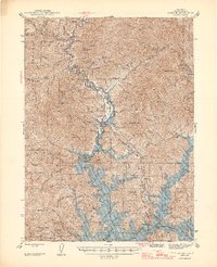
 1969 Lamoine1974 Print · USGSShasta County during the late twentieth century reveals a landscape transformed by the waters of Shasta Lake and the growth of the national forest. Genealogists and researchers can trace the locations of Smithson Sch, the Clipper Mine, and old settlements like Lamoine or Pollock.
 - 1984 Map of Redding
 1984 Redding1984 Print · USGSThe Shasta County region in the mid-1980s reveals a landscape of massive reservoirs and active mining districts. Researchers can trace the development of Redding and Enterprise or locate historic mineral sites like Iron Mountain Mine and Keystone Mine.2 unique versions available
 - 1990 Map of Lamoine
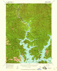
 1990 Lamoine1990 Print · USGSShasta County's Sacramento River canyon is documented here in the early nineties, showing the intersection of mountain settlements and national forest lands. Researchers can trace the development of Lakehead, locate a Prospect near Coal Pit Gulch, and identify old sites like Pollock and Pollard Flat.2 unique versions available
 - 1998 Map of Lamoine, 2003 Print
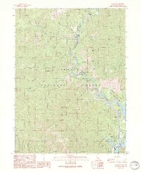
 1998 Lamoine2003 Print · USGSNorthern California river life and forest management are central to this late-nineties survey of the Sacramento River canyon. Researchers can trace historic settlements like Lamoine and Delta alongside landmarks such as the Smithson School and Sugarloaf Lookout Tower.
End of results
Showing maps 1-8 of 8
Frequently asked questions
- What are the different types of historical maps available for Delta?
- What is the oldest map of Delta?
- Where can I purchase historical maps of Delta for my home or office?
- Where can I download high-res historical maps of Delta?
- Are there historical topographic maps available for Delta?
- Is there historical aerial imagery available for Delta?
- Where are historical maps of Delta sourced from?