1990s Maps of Four Corners, California
Explore 2 historic maps of Four Corners from the 1990s. These maps offer a rare glimpse into what life looked like during the 1990s — showing old roads, neighborhoods, homes, and landmarks that have changed or disappeared over time.
Whether you're researching your family's past, planning a metal detecting trip, or studying how Four Corners's landscape evolved across the 1990s, these high-resolution maps are a powerful tool for exploring the history of this region.
- Focus on a specific era: All maps on this page are from the 1990s, giving you a focused view of this time period.
- See what’s changed: Compare century-old streets, trails, and buildings to today's modern landscape using overlays and satellite layers.
- Research with precision: Use these maps for genealogy, historical research, land use analysis, or educational projects.
- View, download, or print: Maps are fully viewable online in high resolution, and can be downloaded or printed for your own records.
Start exploring Four Corners's history through authentic maps from the 1990s. This is your window into the past.
Four Corners, CA maps
(2)- 1990 Map of Burney
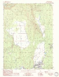 1990 Burney1990 Print · USGSShasta County life in the early nineties is centered on the growing community of Burney and its neighboring Johnson Park. Researchers can trace local landmarks like the Cem, the Goose Valley Ranch, and the Pit 3 Powerhouse along the river.
 - 1995 Map of Burney, 1998 Print
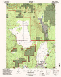 1995 Burney1998 Print · USGSNorthern California timber and ranching life are captured here in the mid-1990s as the community of Burney expands. Researchers can locate the Lumber Mill, trace the Ditch irrigation systems of Goose Valley, or find the Goose Valley Ranch.
End of results
Showing maps 1-2 of 2
Top cities near Four Corners
Frequently asked questions
- What are the different types of historical maps available for Four Corners?
- What is the oldest map of Four Corners?
- Where can I purchase historical maps of Four Corners for my home or office?
- Where can I download high-res historical maps of Four Corners?
- Are there historical topographic maps available for Four Corners?
- Is there historical aerial imagery available for Four Corners?
- Where are historical maps of Four Corners sourced from?