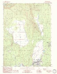
1990 Map of Burney
USGS Topo · Published 1990About this map
Burney serves as the central hub of this northern California landscape, situated at the junction of several prominent natural corridors. The town is flanked by the Shasta National Forest to the north and the Lassen National Forest to the south, highlighting its role as a mountain community focused on forestry and local infrastructure. Significant water-based industry is evident along the Pit River, where the Pit 3 Powerhouse and other installations like the Powerplant near Johnson Park indicate the area's importance for regional hydroelectric power generation.
Find a feature on this map
29 named features on this map. Tap any name to fly to it.
Don’t see what you’re looking for? This feature index may not catch every label — zoom into the map to look around manually.
Map Details
Editions of this 1990 Burney Map
This is the sole edition of this map. No revisions or reprints were ever made.
Other maps of this area

1886 · Lassen Peak
USGS Topo · 1:250,000

1886 · Modoc Lava Bed
USGS Topo · 1:250,000

1892 · Modoc Lava-Bed
USGS Topo · 1:250,000

1892 · Lassen Peak
USGS Topo · 1:250,000

1894 · Lassen Peak
USGS Topo · 1:250,000

1932 · Bartle
USGS Topo · 1:96,000

1935 · Burney
USGS Topo · 1:96,000

1939 · Burney
USGS Topo · 1:125,000

1939 · Bartle
USGS Topo · 1:125,000

1954 · Alturas
USGS Topo · 1:250,000