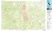
1976 Map of Burney
USGS Topo · Published 1992About this map
Lassen Volcanic National Park dominates the southern landscape of this mid-1970s survey, showcasing a geological theater of volcanic features including Lassen Peak, Chaos Crags, and Cinder Cone. The eastern corridor is defined by the massive basaltic escarpment of the Hat Creek Rim, while the Pit River carves through the northern reaches near Chalk Mountain. This era captures the region's complex land management across the Shasta National Forest and Lassen National Forest, showing the proximity of tribal lands like the Montgomery Creek Indian Rancheria to established settlements such as Burney. The map reveals a high-altitude wilderness shaped by both fire and water, where the Pacific Crest Trail traverses a terrain dotted with alpine lakes like Manzanita Lake and Snag Lake alongside specialized sites like the Poison Station and Bogard Ranger Station.
Find a feature on this map
68 named features on this map. Tap any name to fly to it.
Don’t see what you’re looking for? This feature index may not catch every label — zoom into the map to look around manually.
Map Details
Editions of this 1976 Burney Map
3 editions found
Other maps of this area

1886 · Alturas
USGS Topo · 1:250,000

1886 · Honey Lake
USGS Topo · 1:250,000

1886 · Lassen Peak
USGS Topo · 1:250,000

1886 · Modoc Lava Bed
USGS Topo · 1:250,000

1886 · Shasta
USGS Topo · 1:250,000

1890 · Red Bluff
USGS Topo · 1:250,000

1891 · Honey Lake
USGS Topo · 1:250,000

1892 · Modoc Lava-Bed
USGS Topo · 1:250,000

1892 · Lassen Peak
USGS Topo · 1:250,000

1892 · Alturas
USGS Topo · 1:250,000