Old Maps of Shingletown, California
Explore 40 old maps of Shingletown, spanning from 1886 to today. These high-resolution historic maps reveal how streets, neighborhoods, landmarks, and natural features evolved over time — perfect for genealogy, metal detecting, research, and local history exploration.
What you can do with these maps:
- See how Shingletown changed over time: Compare historical maps to modern-day views to trace roads, homesites, rail lines & more.
- View detailed metadata: Each map includes creators, publishers, year, scale, and archive source.
- Overlay maps with satellite & LiDAR: Visualize the past alongside modern tools to explore terrain & human change.
- Trusted historical sources: Maps sourced from the USGS, Library of Congress, and other archives.
- Access maps your way: View online, download high-res files, or order prints for personal or research use.
Start exploring old maps of Shingletown to uncover forgotten places, hidden landmarks, and the deep history beneath your feet.
Shingletown, CA maps
(40)- 1886 Map of Lassen Peak
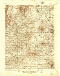
 1886 Lassen Peak1886 Print · USGSThe Cascades of the late nineteenth century appear here as a landscape of timber mills and volcanic peaks. Genealogists and historians can trace early mountain life at Shingletown, Prattville, and isolated industrial sites like Eureka Mill or the Caribou Bridge.
 - 1892 Map of Lassen Peak
 1892 Lassen Peak1892 Print · USGSThe volcanic highlands of the southern Cascades are captured in the late nineteenth century, showing early milling and mountain settlements. Genealogists and historians can trace pioneer sites like Prattville, the old Eureka Mill, and the crossings at Caribou Bridge.
 - 1894 Map of Lassen Peak
 1894 Lassen Peak1894 Print · USGSThe volcanic highlands of Northern California are captured here in the 1890s, shortly after the initial topographic surveys. Genealogists and historians can locate early industry and mountain outposts like Eureka Mill, Prattville, and the remote Hat Creek Post Office.8 unique versions available
 - 1935 Map of Burney
 1935 Burney1935 Print · USGSShasta County's high country is captured in the mid-1930s, showing a transition from ranching to early hydroelectric power. Trace family ranch sites like Armstrong Ranch and long-lost rural schools including Mill Creek Sch and Mountain Grove Sch.2 unique versions available
 - 1935 Map of Paynes Creek
 1935 Paynes Creek1935 Print · USGSUpper Tehama County in the mid-thirties was a hub of mountain industry and early hydroelectric power. Researchers can trace historic family holdings like the Facht Ranch and Wilson Ranch or locate vanished sites like the Forward Mill Camp Forward and Sierra Sch.
 - 1939 Map of Burney
 1939 Burney1939 Print · USGSShasta County mountain life is captured here in the late 1930s, from the volcanic peaks of the Cascades to the timbered ridges above the Pit River. Genealogists can locate family-named landmarks and remote outposts like Montgomery Creek, Doyles Corner, and the Old Mill Site.3 unique versions available
 - 1941 Map of Mineral
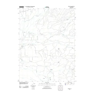
 1941 Mineral1941 Print · USGSThe volcanic highlands of Tehama and Shasta counties come alive in this pre-war survey of the Lassen region. Genealogists and researchers can locate remote family sites like Childs Ranch, the Ishii Caves, and early timber operations at Forward Mill.3 unique versions available
 - 1955 Map of Westwood, 1959 Print
 1955 Westwood1959 Print · USGSIn the mid-fifties, the northeastern California interior supported a landscape of mountain timber and high-desert basins. Genealogists and historians can locate early settlements and industrial sites like Susanville, Herlong, and the Sierra Ordinance Depot.
 - 1956 Map of Manton, 1958 Print
 1956 Manton1958 Print · USGSThe northern California foothills in the mid-fifties show a unique mix of hydroelectric power development and remote mountain ranching. You can trace early 20th-century family holdings like Childs Ranch or explore industrial sites including the Volta Powerhouse and Inskip Powerhouse.2 unique versions available
 - 1956 Map of Whitmore, 1958 Print
 1956 Whitmore1958 Print · USGSShasta County's eastern foothills are shown in the mid-1950s as a landscape of remote ranches and forest management. Researchers can trace family history at Inwood Cemetery, find the Kilarc Powerhouse, or locate the site of the former Ritts Mill.3 unique versions available
 - 1958 Map of Westwood
 1958 Westwood1958 Print · USGSNorthern California in the late fifties shows a landscape of volcanic peaks and rising reservoirs. Researchers can locate the Sierra Ordinance Depot and trace mountain infrastructure through the Hat Creek Ranger Station and Stacy Siding.
 - 1959 Map of Westwood
 1959 Westwood1959 Print · USGSNortheastern California during the late 1950s was a hub of timber, military logistics, and mountain railroading. Researchers can trace the path of the Southern Pacific through the Honey Lake Valley and locate landmarks like the Sierra Ordinance Depot and Lassen Peak.
 - 1962 Map of Susanville, 1965 Print
 1962 Susanville1965 Print · USGSNortheastern California's high desert and volcanic peaks meet in the early sixties, showing the region's timber and rail hubs in transition. Local historians can trace the Southern Pacific lines through Susanville and Litchfield, or explore the sprawling Sierra Army Depot and Lassen Volcanic National Park.2 unique versions available
 - 1968 Map of Susanville
 1968 Susanville1968 Print · USGSThe high Sierras and the Great Basin collide in the late 1960s, showing a landscape of volcanic peaks, timber settlements, and desert plains. Genealogists and researchers can trace historic rail lines like the Western Pacific or locate residents in Susanville, Westwood, and Janesville.
 - 1976 Map of Burney, 1992 Print
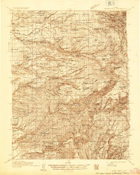
 1976 Burney1992 Print · USGSShasta and Lassen counties come alive in the mid-seventies, documenting a rugged landscape of volcanic peaks and timbered wilderness. Genealogists and hikers can trace the Pacific Crest Trail, early ranger outposts like Poison Station, and tribal lands at Montgomery Creek Indian Rancheria.3 unique versions available
 - 1985 Map of Hagaman Gulch
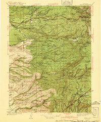
 1985 Hagaman Gulch1985 Print · USGSShasta County during the mid-1980s reveals a transition from timber-producing gulches to high-elevation flats and meadows. Researchers can locate the site of Ritts Mill, trace the springs feeding Hagaman Gulch, and explore family-named landmarks like Dersch Meadows.
 - 1985 Map of Shingletown, 1986 Print
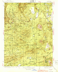
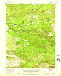
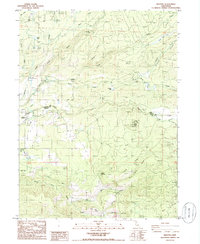
 1985 Shingletown1986 Print · USGSShingletown and the rugged upland between the forks of Battle Creek are captured here in the mid-1980s. Local researchers can trace power and water networks through the Inskip Powerhouse, Darrah Springs State Fish Hatchery, and family landmarks like Long Ranch.
 - 1985 Map of Manton, 1986 Print
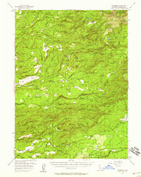
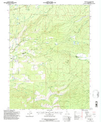
 1985 Manton1986 Print · USGSManton and the Shasta-Tehama county line are captured here in the mid-1980s, revealing a landscape shaped by hydroelectric power and timber. Genealogists and researchers can trace the local Cem, the Volta Powerhouse, and the fire lookout at Lookout Tower Digger Butte.
 - 1985 Map of Inwood, 1986 Print
 1985 Inwood1986 Print · USGSShasta County’s upland drainages are captured in detail during the mid-1980s, showcasing the remote settlements of Inwood and Midway. Researchers can trace local landmarks like the Cemetery, Bear Creek Falls, and several rural Corrals along the many creek forks.
 - 1989 Map of Lake Almanor, 1990 Print
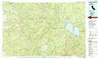 1989 Lake Almanor1990 Print · USGSUpper Plumas and Tehama counties appear here in the late eighties as a landscape of timber, volcanic peaks, and high-country reservoirs. Genealogists and historians can trace settlements from Chester and Westwood to mountain outposts like Mineral and Jonesville.2 unique versions available
 - 1995 Map of Manton, 1997 Print
 1995 Manton1997 Print · USGSThe Shasta and Tehama county line meets in the mid-1990s near the small settlement of Manton. Researchers can trace the region's complex water and power history through the Union Canal, Volta Powerhouse, and the Lookout Digger atop Digger Butte.2 unique versions available
 - 2012 Map of Inwood, 2012 Print
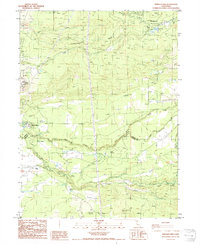
 2012 Inwood2012 Print · USGSCovers Shingletown, including Midway, Redwoods, and other nearby areas
 - 2012 Map of Hagaman Gulch, 2012 Print
 2012 Hagaman Gulch2012 Print · USGSCovers Shingletown, including Shasta County, United States, and other nearby areas
 - 2012 Map of Shingletown, 2012 Print
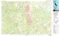
 2012 Shingletown2012 Print · USGSCovers Shingletown, including Manton, Shasta County, and other nearby areas
 - 2012 Map of Manton, 2012 Print
 2012 Manton2012 Print · USGSCovers Shingletown, including Manton, Shasta County, and other nearby areas
Showing maps 1-25 of 40
Top cities near Shingletown
Frequently asked questions
- What are the different types of historical maps available for Shingletown?
- What is the oldest map of Shingletown?
- Where can I purchase historical maps of Shingletown for my home or office?
- Where can I download high-res historical maps of Shingletown?
- Are there historical topographic maps available for Shingletown?
- Is there historical aerial imagery available for Shingletown?
- Where are historical maps of Shingletown sourced from?