1950s Maps of Shingletown, California
Explore 5 historic maps of Shingletown from the 1950s. These maps offer a rare glimpse into what life looked like during the 1950s — showing old roads, neighborhoods, homes, and landmarks that have changed or disappeared over time.
Whether you're researching your family's past, planning a metal detecting trip, or studying how Shingletown's landscape evolved across the 1950s, these high-resolution maps are a powerful tool for exploring the history of this region.
- Focus on a specific era: All maps on this page are from the 1950s, giving you a focused view of this time period.
- See what’s changed: Compare century-old streets, trails, and buildings to today's modern landscape using overlays and satellite layers.
- Research with precision: Use these maps for genealogy, historical research, land use analysis, or educational projects.
- View, download, or print: Maps are fully viewable online in high resolution, and can be downloaded or printed for your own records.
Start exploring Shingletown's history through authentic maps from the 1950s. This is your window into the past.
Shingletown, CA maps
(5)- 1955 Map of Westwood, 1959 Print
 1955 Westwood1959 Print · USGSIn the mid-fifties, the northeastern California interior supported a landscape of mountain timber and high-desert basins. Genealogists and historians can locate early settlements and industrial sites like Susanville, Herlong, and the Sierra Ordinance Depot.
 - 1956 Map of Manton, 1958 Print
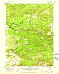 1956 Manton1958 Print · USGSThe northern California foothills in the mid-fifties show a unique mix of hydroelectric power development and remote mountain ranching. You can trace early 20th-century family holdings like Childs Ranch or explore industrial sites including the Volta Powerhouse and Inskip Powerhouse.2 unique versions available
 - 1956 Map of Whitmore, 1958 Print
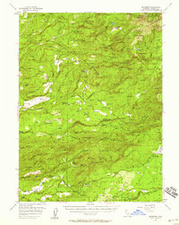 1956 Whitmore1958 Print · USGSShasta County's eastern foothills are shown in the mid-1950s as a landscape of remote ranches and forest management. Researchers can trace family history at Inwood Cemetery, find the Kilarc Powerhouse, or locate the site of the former Ritts Mill.3 unique versions available
 - 1958 Map of Westwood
 1958 Westwood1958 Print · USGSNorthern California in the late fifties shows a landscape of volcanic peaks and rising reservoirs. Researchers can locate the Sierra Ordinance Depot and trace mountain infrastructure through the Hat Creek Ranger Station and Stacy Siding.
 - 1959 Map of Westwood
 1959 Westwood1959 Print · USGSNortheastern California during the late 1950s was a hub of timber, military logistics, and mountain railroading. Researchers can trace the path of the Southern Pacific through the Honey Lake Valley and locate landmarks like the Sierra Ordinance Depot and Lassen Peak.
End of results
Showing maps 1-5 of 5
Top cities near Shingletown
Frequently asked questions
- What are the different types of historical maps available for Shingletown?
- What is the oldest map of Shingletown?
- Where can I purchase historical maps of Shingletown for my home or office?
- Where can I download high-res historical maps of Shingletown?
- Are there historical topographic maps available for Shingletown?
- Is there historical aerial imagery available for Shingletown?
- Where are historical maps of Shingletown sourced from?