1930s Maps of Shingletown, California
Explore 3 historic maps of Shingletown from the 1930s. These maps offer a rare glimpse into what life looked like during the 1930s — showing old roads, neighborhoods, homes, and landmarks that have changed or disappeared over time.
Whether you're researching your family's past, planning a metal detecting trip, or studying how Shingletown's landscape evolved across the 1930s, these high-resolution maps are a powerful tool for exploring the history of this region.
- Focus on a specific era: All maps on this page are from the 1930s, giving you a focused view of this time period.
- See what’s changed: Compare century-old streets, trails, and buildings to today's modern landscape using overlays and satellite layers.
- Research with precision: Use these maps for genealogy, historical research, land use analysis, or educational projects.
- View, download, or print: Maps are fully viewable online in high resolution, and can be downloaded or printed for your own records.
Start exploring Shingletown's history through authentic maps from the 1930s. This is your window into the past.
Shingletown, CA maps
(3)- 1935 Map of Burney
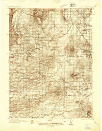 1935 Burney1935 Print · USGSShasta County's high country is captured in the mid-1930s, showing a transition from ranching to early hydroelectric power. Trace family ranch sites like Armstrong Ranch and long-lost rural schools including Mill Creek Sch and Mountain Grove Sch.2 unique versions available
 - 1935 Map of Paynes Creek
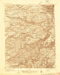 1935 Paynes Creek1935 Print · USGSUpper Tehama County in the mid-thirties was a hub of mountain industry and early hydroelectric power. Researchers can trace historic family holdings like the Facht Ranch and Wilson Ranch or locate vanished sites like the Forward Mill Camp Forward and Sierra Sch.
 - 1939 Map of Burney
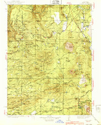 1939 Burney1939 Print · USGSShasta County mountain life is captured here in the late 1930s, from the volcanic peaks of the Cascades to the timbered ridges above the Pit River. Genealogists can locate family-named landmarks and remote outposts like Montgomery Creek, Doyles Corner, and the Old Mill Site.3 unique versions available
End of results
Showing maps 1-3 of 3
Top cities near Shingletown
Frequently asked questions
- What are the different types of historical maps available for Shingletown?
- What is the oldest map of Shingletown?
- Where can I purchase historical maps of Shingletown for my home or office?
- Where can I download high-res historical maps of Shingletown?
- Are there historical topographic maps available for Shingletown?
- Is there historical aerial imagery available for Shingletown?
- Where are historical maps of Shingletown sourced from?