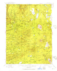
1935 Map of Burney
USGS Topo · Published 1957About this map
Montgomery Creek and the surrounding Shasta County uplands appear here during a period of transition between early pioneer ranching and the expansion of national forest management. This 1930s survey reveals a landscape of isolated family holdings and seasonal settlements like Aubrey Place and Black Ranch, scattered across the complex topography of Goose Valley and the Aubrey Ridge. The presence of several rural educational outposts, including Phillips Sch and Clover Creek Sch, indicates a resident population established well before the modern highway era.
Find a feature on this map
190 named features on this map. Tap any name to fly to it.
Don’t see what you’re looking for? This feature index may not catch every label — zoom into the map to look around manually.
Map Details
Editions of this 1935 Burney Map
2 editions found

Other maps of this area

1886 · Lassen Peak
USGS Topo · 1:250,000

1886 · Modoc Lava Bed
USGS Topo · 1:250,000

1886 · Shasta
USGS Topo · 1:250,000

1890 · Red Bluff
USGS Topo · 1:250,000

1892 · Modoc Lava-Bed
USGS Topo · 1:250,000

1892 · Lassen Peak
USGS Topo · 1:250,000

1894 · Lassen Peak
USGS Topo · 1:250,000

1894 · Red Bluff
USGS Topo · 1:250,000

1894 · Shasta
USGS Topo · 1:250,000

1901 · Redding
USGS Topo · 1:125,000