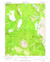
1957 Map of Burney
USGS Topo · Published 1964About this map
Burney sits at the heart of this Shasta County landscape, serving as a hub for the region's timber and hydroelectric operations during the mid-20th century. The presence of several Lumber Mills and the extensive Mc Cloud River Railroad network highlights an economy deeply tied to the surrounding Lassen National Forest. Hydroelectric development is prominent along the Pit River, evidenced by a series of installations including No 1 Powerhouse and No 2 Powerhouse near Lake Britton.
Find a feature on this map
70 named features on this map. Tap any name to fly to it.
Don’t see what you’re looking for? This feature index may not catch every label — zoom into the map to look around manually.
Map Details
Editions of this 1957 Burney Map
2 editions found

Other maps of this area

1886 · Lassen Peak
USGS Topo · 1:250,000

1886 · Modoc Lava Bed
USGS Topo · 1:250,000

1892 · Modoc Lava-Bed
USGS Topo · 1:250,000

1892 · Lassen Peak
USGS Topo · 1:250,000

1894 · Lassen Peak
USGS Topo · 1:250,000

1932 · Bartle
USGS Topo · 1:96,000

1935 · Burney
USGS Topo · 1:96,000

1939 · Burney
USGS Topo · 1:125,000

1939 · Halls Flat
USGS Topo · 1:125,000

1939 · Bartle
USGS Topo · 1:125,000