
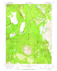
1957 Map of Burney
USGS Topo · Published 1959About this map
The timber and water resources of eastern Shasta County take center stage in this mid-century survey, dominated by the massive profile of Burney Mtn and the expansive Lassen National Forest. The town of Burney serves as a central hub, surrounded by active industrial and agricultural sites like the Lumber Mill to the north and numerous family-run operations including Goose Valley Ranch and Black Ranch. The landscape is a complex network of volcanic buttes and spring-fed water systems, where the Pit River flows into Lake Britton near No 2 Powerhouse. Local infrastructure is well-defined, from the Albion School and Lincoln School to the Hat Creek Ranger Station. A notable Railroad Grade cuts through the terrain near Jackrabbit Flat, indicating the historical path of logging and transport through these foothills before the late 1950s.
Find a feature on this map
65 named features on this map. Tap any name to fly to it.
Don’t see what you’re looking for? This feature index may not catch every label — zoom into the map to look around manually.
Map Details
Editions of this 1957 Burney Map
2 editions found
Other maps of this area

1886 · Lassen Peak
USGS Topo · 1:250,000

1886 · Modoc Lava Bed
USGS Topo · 1:250,000

1892 · Modoc Lava-Bed
USGS Topo · 1:250,000

1892 · Lassen Peak
USGS Topo · 1:250,000

1894 · Lassen Peak
USGS Topo · 1:250,000

1932 · Bartle
USGS Topo · 1:96,000

1935 · Burney
USGS Topo · 1:96,000

1939 · Burney
USGS Topo · 1:125,000

1939 · Halls Flat
USGS Topo · 1:125,000

1939 · Bartle
USGS Topo · 1:125,000