1960s Maps of Redding, California
Explore 2 historic maps of Redding from the 1960s. These maps offer a rare glimpse into what life looked like during the 1960s — showing old roads, neighborhoods, homes, and landmarks that have changed or disappeared over time.
Whether you're researching your family's past, planning a metal detecting trip, or studying how Redding's landscape evolved across the 1960s, these high-resolution maps are a powerful tool for exploring the history of this region.
- Focus on a specific era: All maps on this page are from the 1960s, giving you a focused view of this time period.
- See what’s changed: Compare century-old streets, trails, and buildings to today's modern landscape using overlays and satellite layers.
- Research with precision: Use these maps for genealogy, historical research, land use analysis, or educational projects.
- View, download, or print: Maps are fully viewable online in high resolution, and can be downloaded or printed for your own records.
Start exploring Redding's history through authentic maps from the 1960s. This is your window into the past.
Redding, CA maps
(2)- 1964 Map of Olinda, 1966 Print
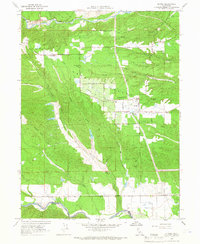 1964 Olinda1966 Print · USGSShasta County's gold-mining legacy and agricultural growth are visible here in the mid-1960s, showing a landscape shaped by both industry and settlement. Genealogists can trace family footprints near Olinda, Cloverdale, and the Happy Valley Sch while mapping the extensive Dredge Tailings along the gulches.4 unique versions available
 - 1965 Map of Cottonwood, 1966 Print
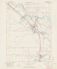 1965 Cottonwood1966 Print · USGSShasta and Tehama counties appear during a period of agricultural and industrial transition in the mid-sixties. Researchers can trace the Southern Pacific rail line and irrigation networks alongside local landmarks like the Oddfellows Cem and Shasta District Fairgrounds.3 unique versions available
End of results
Showing maps 1-2 of 2
Top cities near Redding
- Anderson historical maps
- Shasta Lake historical maps
- Cottonwood historical maps
- Cottonwood historical maps
- Millville historical maps
Top neighborhoods of Redding
- Enterprise historical maps
- Enterprise Acres historical maps
- Alta Mesa historical maps
- Saratoga historical maps
- Buckeye historical maps
- Clay Street historical maps
See more
Frequently asked questions
- What are the different types of historical maps available for Redding?
- What is the oldest map of Redding?
- Where can I purchase historical maps of Redding for my home or office?
- Where can I download high-res historical maps of Redding?
- Are there historical topographic maps available for Redding?
- Is there historical aerial imagery available for Redding?
- Where are historical maps of Redding sourced from?