1940s Maps of Redding, California
Explore 4 historic maps of Redding from the 1940s. These maps offer a rare glimpse into what life looked like during the 1940s — showing old roads, neighborhoods, homes, and landmarks that have changed or disappeared over time.
Whether you're researching your family's past, planning a metal detecting trip, or studying how Redding's landscape evolved across the 1940s, these high-resolution maps are a powerful tool for exploring the history of this region.
- Focus on a specific era: All maps on this page are from the 1940s, giving you a focused view of this time period.
- See what’s changed: Compare century-old streets, trails, and buildings to today's modern landscape using overlays and satellite layers.
- Research with precision: Use these maps for genealogy, historical research, land use analysis, or educational projects.
- View, download, or print: Maps are fully viewable online in high resolution, and can be downloaded or printed for your own records.
Start exploring Redding's history through authentic maps from the 1940s. This is your window into the past.
Redding, CA maps
(4)- 1944 Map of Redding, 1957 Print
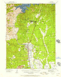 1944 Redding1957 Print · USGSShasta County during the mid-1940s was a landscape in transition, anchored by the recently completed Shasta Dam and the bustling rail hub of Redding. Family historians and researchers can pinpoint long-standing schools like Grant School and trace industrial sites from the Walker Mine to Benton Airport.2 unique versions available
 - 1946 Map of Redding
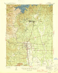 1946 Redding1946 Print · USGSShasta County underwent a massive transformation in the mid-forties following the completion of Shasta Dam. Researchers can trace the rise of boomtowns like Project City alongside legacy mining operations such as the Balaklala Mine and Yankee John Mine.2 unique versions available
 - 1947 Map of Anderson, 1963 Print
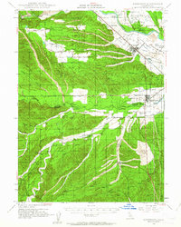 1947 Anderson1963 Print · USGSShasta and Tehama counties appear here in the late 1940s as a thriving corridor of riverside ranching and rail transport. Researchers can trace family sites like Gaines Ranch, early rural schools including Farquhar Sch, and the historical path of the Southern Pacific Railroad.2 unique versions available
 - 1948 Map of Anderson
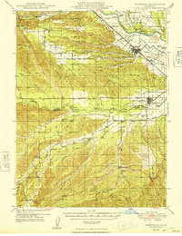 1948 Anderson1948 Print · USGSThe northern Sacramento Valley is captured here in the late 1940s, anchored by the rail corridor and the winding Sacramento River. Genealogists can trace family landmarks like Baker Ranch, Cloverdale Cem, and the rural Evergreen Sch.2 unique versions available
End of results
Showing maps 1-4 of 4
Top cities near Redding
- Anderson historical maps
- Shasta Lake historical maps
- Cottonwood historical maps
- Cottonwood historical maps
- Millville historical maps
Top neighborhoods of Redding
- Enterprise historical maps
- Enterprise Acres historical maps
- Alta Mesa historical maps
- Saratoga historical maps
- Buckeye historical maps
- Clay Street historical maps
See more
Frequently asked questions
- What are the different types of historical maps available for Redding?
- What is the oldest map of Redding?
- Where can I purchase historical maps of Redding for my home or office?
- Where can I download high-res historical maps of Redding?
- Are there historical topographic maps available for Redding?
- Is there historical aerial imagery available for Redding?
- Where are historical maps of Redding sourced from?