1950s Maps of Redding, California
Explore 5 historic maps of Redding from the 1950s. These maps offer a rare glimpse into what life looked like during the 1950s — showing old roads, neighborhoods, homes, and landmarks that have changed or disappeared over time.
Whether you're researching your family's past, planning a metal detecting trip, or studying how Redding's landscape evolved across the 1950s, these high-resolution maps are a powerful tool for exploring the history of this region.
- Focus on a specific era: All maps on this page are from the 1950s, giving you a focused view of this time period.
- See what’s changed: Compare century-old streets, trails, and buildings to today's modern landscape using overlays and satellite layers.
- Research with precision: Use these maps for genealogy, historical research, land use analysis, or educational projects.
- View, download, or print: Maps are fully viewable online in high resolution, and can be downloaded or printed for your own records.
Start exploring Redding's history through authentic maps from the 1950s. This is your window into the past.
Redding, CA maps
(5)- 1956 Map of Shasta Dam, 1958 Print
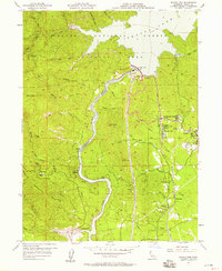 1956 Shasta Dam1958 Print · USGSMid-century Shasta County undergoes a radical transformation as the completion of Shasta Dam reshapes the canyon. Trace the development of Summit City, the infrastructure of Government Camp, and legacy mines like the Uncle Sam Mine.5 unique versions available
 - 1957 Map of Redding, 1958 Print
 1957 Redding1958 Print · USGSRedding and its surrounding gold-country landscapes are captured here during a period of significant mid-century growth. Genealogists and historians can trace family locations near the Middletown Cem, identify early sites like Shasta, or locate the Yankee John Mine among the foothills.4 unique versions available
 - 1957 Map of Enterprise, 1958 Print
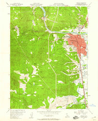
 1957 Enterprise1958 Print · USGSShasta County experienced a surge of mid-century development east of the Sacramento River during the late fifties. Researchers can trace early suburban growth through sites like Enterprise High Sch, Loomis Corners, and the Redding Municipal Airport.6 unique versions available
 - 1957 Map of Project City, 1958 Print
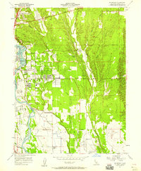
 1957 Project City1958 Print · USGSShasta County during the late 1950s shows the growth of communities like Project City and Central Valley alongside the rising waters of Shasta Lake. Researchers can locate mid-century landmarks such as the Bass Sch, the Southern Pacific rail line, and the small settlements of Newtown and Pine Grove.4 unique versions available
 - 1958 Map of Redding
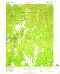
 1958 Redding1958 Print · USGSNorthern California's valley and mountain landscapes are captured in the late fifties, showing the region as new reservoirs reshaped the river systems. Genealogists and historians can trace rail-side towns like Cottonwood, the military presence at Red Bluff Air Force Station, and mountain outposts like Weaverville.5 unique versions available
End of results
Showing maps 1-5 of 5
Top cities near Redding
- Anderson historical maps
- Shasta Lake historical maps
- Cottonwood historical maps
- Cottonwood historical maps
- Millville historical maps
Top neighborhoods of Redding
- Enterprise historical maps
- Enterprise Acres historical maps
- Alta Mesa historical maps
- Saratoga historical maps
- Buckeye historical maps
- Clay Street historical maps
See more
Frequently asked questions
- What are the different types of historical maps available for Redding?
- What is the oldest map of Redding?
- Where can I purchase historical maps of Redding for my home or office?
- Where can I download high-res historical maps of Redding?
- Are there historical topographic maps available for Redding?
- Is there historical aerial imagery available for Redding?
- Where are historical maps of Redding sourced from?